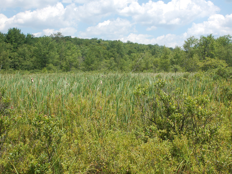
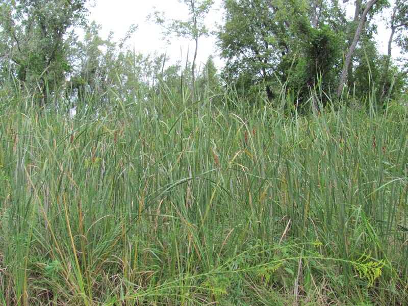
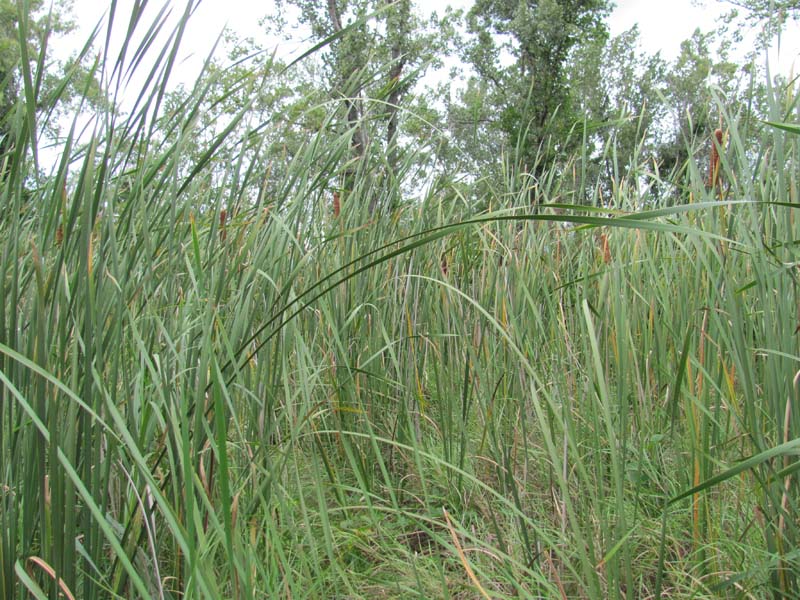
Cat-tail Marsh
System: Palustrine
Subsystem: Herbaceous
PA Ecological Group(s): Marsh Wetland and Basin Wetland
Global Rank:GNR
![]() rank interpretation
rank interpretation
State Rank: S5
General Description
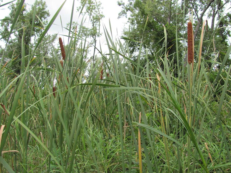
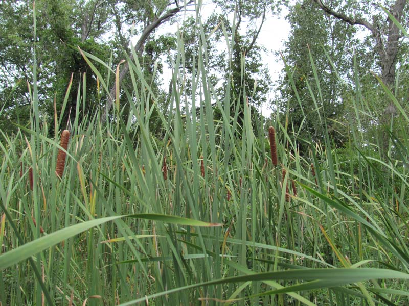
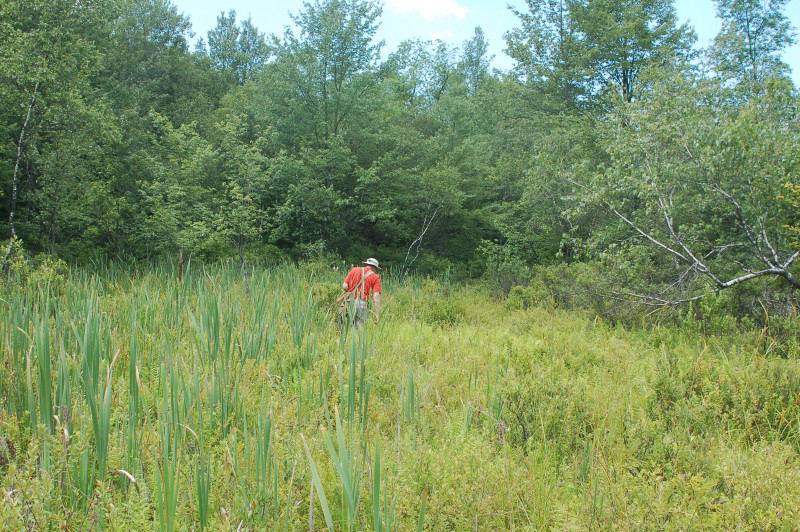
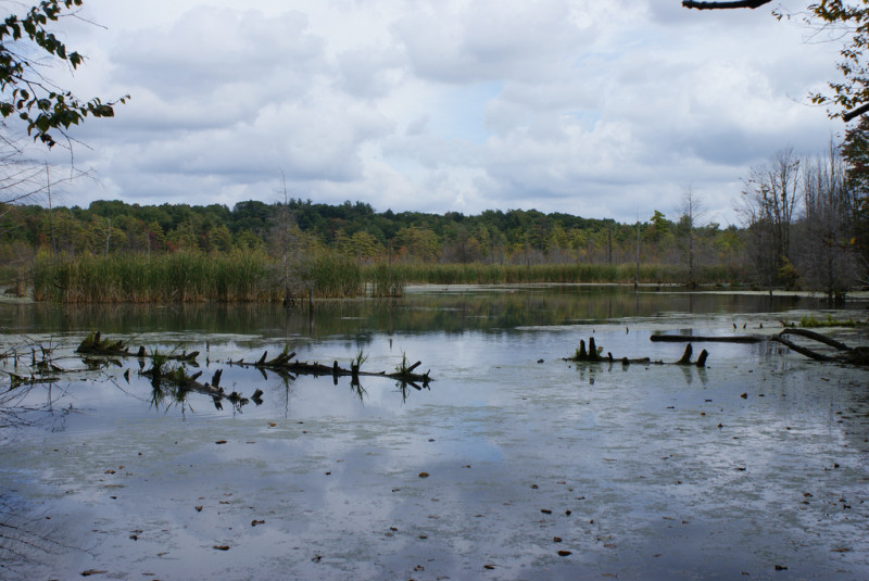
These are robust emergent marshes dominated by common cat-tail (Typha latifolia), or less commonly, narrow-leaved cat-tail (Typha angustifolia). This type can occur in a variety of landscape positions including river backwaters, protected pond and lakeshores, and upland depressions. Shrubs may be present but cover less than 20%. This community is also common in disturbed landscapes (e.g., roadside ditches, storm water detention basins, disturbed portions of other wetland communities), where bare soil is available for colonization. This community may also occur where other wetland types have experienced an increase in nutrients, such as fertilizer run-off. The substrate may be muck or mineral soil. The surface is usually flooded for most of the year. Associated species include wool-grass (Scirpus cyperinus), arrow-arum (Peltandra virginica), bur-reed (Sparganium americanum), sensitive fern (Onoclea sensibilis), jewelweed (Impatiens capensis), pickerel-weed (Pontederia cordata), wapato (Sagittaria latifolia), beggar-ticks (Bidens spp.), smartweeds (Persicaria spp.), duckweed (Lemna minor), and sedges (Carex spp.) – especially tussock sedge (C. stricta). The invasive species common reed (Phragmites australis ssp. australis), narrow-leaved cat-tail (Typha angustifolia), and purple loosestrife (Lythrum salicaria) are frequently a major problem in these systems.
Rank Justification
Common, widespread, and abundant in the jurisdiction.
Identification
- River backwaters, protected pond and lakeshores, and upland depressions
- Often associated with disturbed wetlands
- Substrate may be muck or mineral soil
- Surface is usually flooded for most of the year
- Dominated by common cat-tail (Typha latifolia)
Herbs
- Common cat-tail (Typha latifolia)
- Narrow-leaved cat-tail (Typha angustifolia)
- Wool-grass (Scirpus cyperinus)
- Bur-reed (Sparganium americanum)
- Sensitive fern (Onoclea sensibilis)
- Jewelweed (Impatiens capensis)
- Pickerel-weed (Pontederia cordata)
- Wapato (Sagittaria latifolia)
- Beggar-ticks (Bidens spp.)
- Tearthumb (Persicaria sagittata)
- Dotted smartweed (Persicaria punctata)
- Mild water-pepper (Persicaria hydropiperoides)
- Sedge (Carex stipata)
- Sedge (Carex lurida)
- Sedge (Carex gynandra)
- Broom sedge (Carex scoparia)
- Sedge (Carex tribuloides)
- Sedge (Carex projecta)
- Sedge (Carex lacustris)
- Sedges (Carex spp.)
- Tussock sedge (Carex stricta)
- Duckweed (Lemna spp.)
Exotic Species
* limited to sites with higher soil calcium
Vascular plant nomenclature follows Rhoads and Block (2007). Bryophyte nomenclature follows Crum and Anderson (1981).
International Vegetation Classification Associations:
USNVC Crosswalk:None
Representative Community Types:
Eastern Cattail Marsh (CEGL006153)
NatureServe Ecological Systems:
Laurentian-Acadian Freshwater Marsh (CES201.594)
NatureServe Group Level:
None
Origin of Concept
Fike, J. 1999. Terrestrial and palustrine plant communities of Pennsylvania. Pennsylvania Natural Diversity Inventory. Pennsylvania Department of Conservation and Recreation, Bureau of Forestry, Harrisburg, PA. 86 pp.
Pennsylvania Community Code*
HC : Cattail Marsh
*(DCNR 1999, Stone 2006)
Similar Ecological Communities
Clear dominance by cat-tail (Typha spp.) distinguishes this type from the other marsh/palustrine herbaceous types that occur in similar settings.
Fike Crosswalk
Cat-tail Marsh
Conservation Value
Cat-tail Marsh can serve as an important habitat and food source for muskrats and shorebirds, such as the Marsh Wren (Cistothorus palustris) and American Bittern (Botaurus lentiginosus). This community also serves as a buffer for sediment and pollution runoff from adjacent developed lands by slowing the flow of surficial water causing sediment to settle within this wetland.
Threats
Alteration to the hydrological regime and development are the major threats to this community (e.g., impoundments, beaver dams) and can lead to habitat destruction and/or shifts in community function and dynamics. Clearing and development of adjacent land can lead to an accumulation of agricultural run-off and pollution as well as sedimentation. Invasive plant species such as purple loosestrife (Lythrum salicaria) and common reed (Phragmites australis) can occur in this community. Cat-tail Marsh communities themselves can be a threat to other wetland communities through the clonal growth of cat-tails and displacement of other vegetation types.
Management
A natural buffer around the wetland should be maintained in order to minimize nutrient runoff, pollution, and sedimentation. The potential for soil erosion based on soil texture, condition of the adjacent vegetation (mature forests vs. clearcuts) and the topography of the surrounding area (i.e., degree of slope) should be considered when establishing buffers. The buffer size should be increased if soils are erodible, adjacent vegetation has been logged, and the topography is steep as such factors could contribute to increased sedimentation and nutrient pollution. Direct impacts and habitat alteration should be avoided (e.g., roads, trails, filling of wetlands) and low impact alternatives (e.g., elevated footpaths, boardwalks, bridges) should be utilized in situations where accessing the wetland can not be avoided. Care should also be taken to control and prevent the spread of invasive species within the wetland.
Research Needs
There is a need to collect plot data to characterize variations and guide further classification of this community.
Trends
It is difficult to characterize the trend of this community but it typically occurs in degraded wetlands. Wetland protection has most likely stabilized the decline of these communities. The relative trend for this community is likely stable or may be increasing slightly due to hydrological alterations.
Range Map
Pennsylvania Range
Statewide
Global Distribution
Connecticut, Delaware, Maine, Maryland, Massachusetts, North Carolina, New Hampshire, New Jersey, New York, Pennsylvania, Rhode Island, Virginia, Vermont, and West Virginia.
Breden, T. F. 1989. A preliminary natural community classification for New Jersey. Pages 157-191 in: E. F. Karlin, editor. New Jersey's rare and endangered plants and animals. Institute for Environmental Studies, Ramapo College, Mahwah, NJ. 280 pp.
Breden, T. F., Y. R. Alger, K. S. Walz, and A. G. Windisch. 2001. Classification of vegetation communities of New Jersey: Second iteration. Association for Biodiversity Information and New Jersey Natural Heritage Program, Office of Natural Lands Management, Division of Parks and Forestry, New Jersey Department of Environmental Protection, Trenton.
CAP [Central Appalachian Forest Working Group]. 1998. Central Appalachian Working group discussions. The Nature Conservancy, Boston, MA.
Clancy, K. 1996. Natural communities of Delaware. Unpublished review draft. Delaware Natural Heritage Program, Division of Fish and Wildlife, Delaware Division of Natural Resources and Environmental Control, Smyrna, DE. 52 pp.
Cowardin, L. M., V. Carter, F. C. Golet, and E. T. LaRoe. 1979. Classification of wetlands and deepwater habitats of the United States. U.S. Fish and Wildlife Service, Biological Service Program. FWS/OBS-79/31. Washington, DC. 103 pp.
Eastern Ecology Working Group of NatureServe. No date. International Ecological Classification Standard: International Vegetation Classification. Terrestrial Vegetation. NatureServe, Boston, MA.
Edinger, G. J., D. J. Evans, S. Gebauer, T. G. Howard, D. M. Hunt, and A. M. Olivero, editors. 2002. Ecological communities of New York state. Second edition. A revised and expanded edition of Carol Reschke's ecological communities of New York state. (Draft for review). New York Natural Heritage Program, New York State Department of Environmental Conservation, Albany, NY.
Fike, J. 1999. Terrestrial and palustrine plant communities of Pennsylvania. Pennsylvania Natural Diversity Inventory. Pennsylvania Department of Conservation and Recreation. Bureau of Forestry. Harrisburg, PA. 86 pp.
Gawler, S. C. 2002. Natural landscapes of Maine: A guide to vegetated natural communities and ecosystems. Maine Natural Areas Program, Department of Conservation, Augusta, ME. [in press]
Grace, J. B., and R. G. Wetzel. 1981. Habitat partitioning and competitive displacement in cattail (Typha): Experimental field studies. The American Midland Naturalist 118:463-474.
Harrison, J. W., compiler. 2004. Classification of vegetation communities of Maryland: First iteration. A subset of the International Classification of Ecological Communities: Terrestrial Vegetation of the United States, NatureServe. Maryland Natural Heritage Program, Maryland Department of Natural Resources, Annapolis. 243 pp.
Horvath, Jamie L., Timothy A. Block, and Ann F. Rhoads. 2008. Description of the population, canopy cover, and associated vegetation of the globally rare sedge Carex polymorpha (Cyperaceae) in Nescopeck State Park, Pennsylvania. In Sedges: Uses, Diversity, and Systematics of the Cyperaceae, eds. R. Naczi and B. Ford. Missouri Botanical Garden Press, St. Louis, MO.
Metzler, K. J., and J. P. Barrett. 2001. Vegetation classification for Connecticut. Draft 5/21/2001. Connecticut Department of Environmental Protection, Natural Resources Center, Natural Diversity Database, Hartford.
NatureServe 2010. NatureServe Explorer: An online encyclopedia of life Version 7.1. NatureServe, Arlington, VA. Available http://www.natureserv.org/explorer (accessed: 23 November 2011).
Northern Appalachian Ecology Working Group. 2000. Northern Appalachian / Boreal Ecoregion community classification (Review Draft). The Nature Conservancy, Eastern Conservation Science Center, Boston, MA. 117 pp. plus appendices.
NRCS [Natural Resources Conservation Service]. 2004. Soil survey of Saratoga County, New York. USDA Natural Resources Conservation Service. 590 pp.
Pennsylvania Department of Conservation and Natural Resources (DCNR). 1999. Inventory Manual of Procedure. For the Fourth State Forest Management Plan. Pennsylvania Bureau of Forestry, Division of Forest Advisory Service. Harrisburg, PA. 51 ppg.
Rawinski, T. 1984. Natural community description abstract - southern New England calcareous seepage swamp. Unpublished report. The Nature Conservancy, Boston, MA. 6 pp.
Rhoads, Ann F. and Timothy A. Block. 1999. Natural Areas Inventory of Bucks County, Pennsylvania. Bucks County Commissioners, Doylestown, PA.
Rhoads, Ann F. and Timothy A. Block. 2002. Nescopeck State Park; Inventory of PNDI-listed Plants and Plant Communities. Report submitted to DCNR, Bureau of State Parks.
Sperduto, D. D., and W. F. Nichols. 2004. Natural communities of New Hampshire: A guide and classification. New Hampshire Natural Heritage Inventory, DRED Division of Forests and Lands, Concord. 242 pp.
Stone, B., D. Gustafson, and B. Jones. 2006 (revised). Manual of Procedure for State Game Land Cover Typing. Commonwealth of Pennsylvania Game Commission, Bureau of Wildlife Habitat Management, Forest Inventory and Analysis Section, Forestry Division. Harrisburg, PA. 79 ppg.
Swain, P. C., and J. B. Kearsley. 2001. Classification of natural communities of Massachusetts. September 2001 draft. Natural Heritage and Endangered Species Program, Massachusetts Division of Fisheries and Wildlife. Westborough, MA.
Thompson, E. 1996. Natural communities of Vermont uplands and wetland. Nongame and Natural Heritage Program, Department of Fish and Wildlife in cooperation with The Nature Conservancy, Vermont chapter. 34 pp.
Thompson, E. H., and E. R. Sorenson. 2000. Wetland, woodland, wildland: A guide to the natural communities of Vermont. The Nature Conservancy and the Vermont Department of Fish and Wildlife. University Press of New England, Hanover, NH. 456 pp.
Cite as:
Eichelberger, B. 2022. Pennsylvania Natural Heritage Program. Cat-tail Marsh Factsheet. Available from: https://www.naturalheritage.state.pa.us/Community.aspx?=16002 Date Accessed: January 13, 2026


