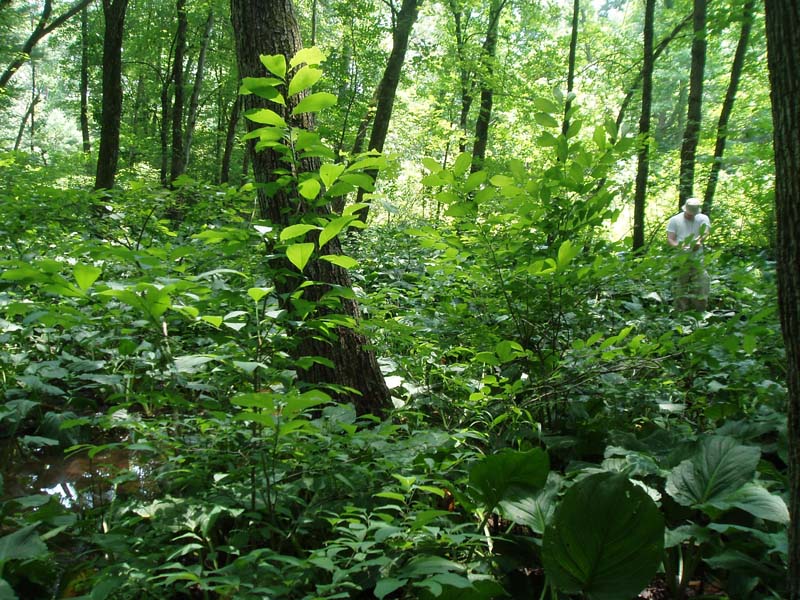
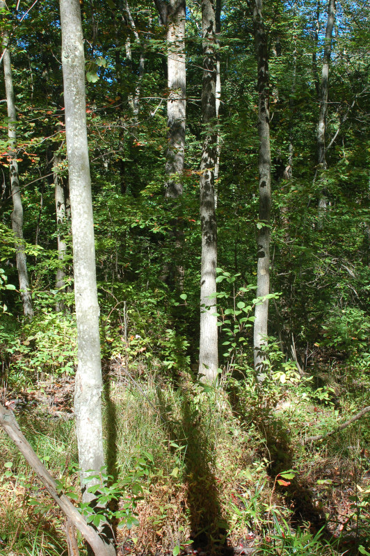
Red Maple – Black Ash Palustrine Forest
System: Palustrine
Subsystem: Forest
PA Ecological Group(s):
Basin Wetland
Global Rank:G2G4
![]() rank interpretation
rank interpretation
State Rank: S2S3
General Description
These are palustrine forests enriched by groundwater, varying from circumneutral to calcareous. The substrate can be muck or mineral soil with or without a thin layer of organic matter. Calciphiles are often present. The dominant trees are usually red maple (Acer rubrum) and black ash (Fraxinus nigra). Associates include swamp white oak (Quercus bicolor), blackgum (Nyssa sylvatica), and American elm (Ulmus americana). Common understory species include meadow-sweets (Spiraea latifolia, S. alba), winterberry (Ilex verticillata), and alders (Alnus serrulata or A. incana ssp. rugosa. Alder-leaved buckthorn (Rhamnus alnifolia) and poison sumac (Toxicodendron vernix) may be present in the more calcareous sites. Common herbs include royal fern (Osmunda regalis), tussock sedge (Carex stricta), a sedge (Carex leptalea), skunk-cabbage (Symplocarpus foetidus), violets (Viola spp.), water avens (Geum rivale), and sensitive fern (Onoclea sensibilis). Many calciphilic species associated with this type have moderate to high light requirements, and thus are found in openings. These species include hemlock-parsley (Conioselinum chinense), spreading globe-flower (Trollius laxus), sedges (Carex interior, C. flava, C. lacustris, C. laevivaginata), small yellow lady's-slipper (Cypripedium parviflorum var. parviflorum), showy lady's-slipper (Cypripedium reginae), and downy willow-herb (Epilobium strictum).
Rank Justification
Vulnerable in the jurisdiction due to a restricted range, relatively few populations, recent and widespread declines, or other factors making it vulnerable to extirpation.
Identification
- Poorly drained depressions with primarily organic soils
- Typically underlain by calcareous bedrock or calcareous glacial deposits
- Canopy dominated by red maple (Acer rubrum) and black ash (Fraxinus nigra)
- Ground-fed circumneutral water
- May have openings with calciphilic species such as hemlock-parsley (Conioselinum chinense), spreading globe-flower (Trollius laxus), sedges (Carex interior, C. flava, C. lacustris, C. laevivaginata), small yellow lady's-slipper (Cypripedium parviflorum var. parviflorum), showy lady's-slipper (Cypripedium reginae), and downy willow-herb (Epilobium strictum)
Trees
Shrubs
Herbs
- Sedge (Carex interior)
- Sedge (Carex leptalea)
- Yellow lady's-slipper (Cypripedium parviflorum var. parviflorum)
- Showy lady's-slipper (Cypripedium reginae)
- Water avens (Geum rivale)
- Downy willow-herb (Epilobium strictum)
- Cinnamon fern (Osmunda cinnamomea)
- Tussock sedge (Carex stricta)
- Skunk cabbage (Symplocarpus foetidus)
- Violets (Viola spp.)
- Sensitive fern (Onoclea sensibilis)
- Hemlock-parsley (Conioselinum chinense)
- Spreading globe-flower (Trollius laxus)
* limited to sites with higher soil calcium
Vascular plant nomenclature follows Rhoads and Block (2007). Bryophyte nomenclature follows Crum and Anderson (1981).
International Vegetation Classification Associations:
USNVC Crosswalk:None
Representative Community Types:
Red Maple - Black Ash Swamp (CEGL007441)
NatureServe Ecological Systems:
North-Central Interior and Appalachian Rich Swamp (CES202.605)
NatureServe Group Level:
None
Origin of Concept
Fike, J. 1999. Terrestrial and palustrine plant communities of Pennsylvania. Pennsylvania Natural Diversity Inventory. Pennsylvania Department of Conservation and Recreation, Bureau of Forestry, Harrisburg, PA. 86 pp.
Pennsylvania Community Code*
UC : Red Maple – Black Ash Palustrine Forest
*(DCNR 1999, Stone 2006)
Similar Ecological Communities
The much more common Red Maple – Blackgum Palustrine Forest is not generally influenced by calcareous waters, and lacks the black ash (Fraxinus nigra) and herbaceous calciphiles that characterize the Red Maple – Black Ash Palustrine Forest.
Red Maple – Black Ash Palustrine Forest may contain pin oak (Quercus palustris) and swamp white oak (Quercus bicolor) which dominate the Oak - Mixed Hardwood Palustrine Forest but the Red Maple – Black Ash Palustrine Forest is clearly dominated by red maple (Acer rubrum) and black ash (Fraxinus nigra).
Fike Crosswalk
Red maple - black ash palustrine forest
Conservation Value
The community supports calciphilic and rare plant species including spreading globe-flower (Trollius laxus), yellow sedge (Carex flava), small yellow lady's-slipper (Cypripedium parviflorum var. parviflorum), showy lady's-slipper (Cypripedium reginae), and swamp red currant (Ribes triste). This community also serves as a buffer for sediment and pollution runoff from adjacent developed lands by slowing the flow of surficial water causing sediment to settle within this wetland.
Threats
Alteration to the current hydrological regime is a major threat to this community and can lead to habitat destruction and/or shifts in community function and dynamics. Clearing and development of adjacent land can lead to an accumulation of agricultural run-off and pollution, sedimentation, and insolation/thermal pollution. Invasive plant species such as purple loosestrife (Lythrum salicaria) and Japanese stiltgrass (Microstegium vimineum) can be common in this community. Ash (Fraxinus spp.) mortality resulting from the emerald ash borer (Agrilus planipennis)is a major concern.
Management
A natural buffer around the wetland should be maintained in order to minimize nutrient runoff, pollution, and sedimentation. The potential for soil erosion based on soil texture, condition of the adjacent vegetation (mature forests vs. clearcuts), and the topography of the surrounding area (i.e., degree of slope) should be considered when establishing buffers. The buffer size should be increased if soils are erodible, adjacent vegetation has been logged, and the topography is steep as such factors could contribute to increased sedimentation and nutrient pollution. Direct impacts and habitat alteration should be avoided (e.g., roads, trails, filling of wetlands) and low impact alternatives (e.g., elevated footpaths, boardwalks, bridges) should be utilized in situations where accessing the wetland can not be avoided. Care should also be taken to control and prevent the spread of invasive species within the wetland. Alterations to groundwater sources should be minimized.
Research Needs
Variations may occur at ecoregional levels. There is a need to collect additional plot data to characterize variations and guide further classification of this community.
Trends
Red Maple – Black Ash Palustrine Forests were probably more common but declined due to dam impoundments, wetland draining/filling, and clearing of the adjacent lands leading to increased sedimentation and disruption of wetland hydrology. The relative trend for this community is likely stable or may be declining slightly due to hydrological alterations.
Range Map
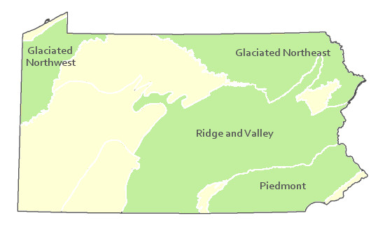
Pennsylvania Range
Glaciated Northeast, Glaciated Northwest, Piedmont, Ridge and Valley.
Global Distribution
Maryland, New York, Pennsylvania, and West Virginia.
Breden, T. F., Y. R. Alger, K. S. Walz, and A. G. Windisch. 2001. Classification of vegetation communities of New Jersey: Second iteration. Association for Biodiversity Information and New Jersey Natural Heritage Program, Office of Natural Lands Management, Division of Parks and Forestry, New Jersey Department of Environmental Protection, Trenton.
Byers, E. A., J. P. Vanderhorst, and B. P. Streets. 2007. Classification and conservation assessment of high elevation wetland communities in the Allegheny Mountains of West Virginia. West Virginia Natural Heritage Program, West Virginia Division of Natural Resources, Elkins.
Cowardin, L. M., V. Carter, F. C. Golet, and E. T. LaRoe. 1979. Classification of wetlands and deepwater habitats of the United States. U.S. Fish and Wildlife Service, Biological Service Program. FWS/OBS-79/31. Washington, DC. 103 pp.
Edinger, G. J., D. J. Evans, S. Gebauer, T. G. Howard, D. M. Hunt, and A. M. Olivero, editors. 2002. Ecological communities of New York state. Second edition. A revised and expanded edition of Carol Reschke's ecological communities of New York state. (Draft for review). New York Natural Heritage Program, New York State Department of Environmental Conservation, Albany, NY.
Fike, J. 1999. Terrestrial and palustrine plant communities of Pennsylvania. Pennsylvania Natural Diversity Inventory. Pennsylvania Department of Conservation and Recreation. Bureau of Forestry. Harrisburg, PA. 86 pp.
Gawler, S. C. 2002. Natural landscapes of Maine: A guide to vegetated natural communities and ecosystems. Maine Natural Areas Program, Department of Conservation, Augusta, ME.
Harrison, J. W., compiler. 2004. Classification of vegetation communities of Maryland: First iteration. A subset of the International Classification of Ecological Communities: Terrestrial Vegetation of the United States, NatureServe. Maryland Natural Heritage Program, Maryland Department of Natural Resources, Annapolis. 243 pp.
Metzler, K. J., and J. P. Barrett. 2001. Vegetation classification for Connecticut. Connecticut Department of Environmental Protection, Natural Resources Center, Natural Diversity Database, Hartford.
NatureServe 2010. NatureServe Explorer: An online encyclopedia of life Version 7.1. NatureServe, Arlington, VA. Available http://www.natureserv.org/explorer (accessed: 23 November 2011).
Pennsylvania Department of Conservation and Natural Resources (DCNR). 1999. Inventory Manual of Procedure. For the Fourth State Forest Management Plan. Pennsylvania Bureau of Forestry, Division of Forest Advisory Service. Harrisburg, PA. 51 ppg.
Rhoads, Ann F. and Timothy A. Block. 2008. Natural Areas Inventory Update, Montgomery County, Pennsylvania. Montgomery County Planning Commission, Norristown, PA.
Rhoads, Ann F. and Timothy A. Block. 2008. Natural Resources Inventory of French Creek State Park. Report submitted to DCNR, Bureau of State Parks.
Sperduto, D. D. 2000b. A classification of wetland natural communities in New Hampshire. New Hampshire Natural Heritage Inventory, Department of Resources and Economic Development, Division of Forests and Lands. Concord, NH. 156 pp.
Stone, B., D. Gustafson, and B. Jones. 2006 (revised). Manual of Procedure for State Game Land Cover Typing. Commonwealth of Pennsylvania Game Commission, Bureau of Wildlife Habitat Management, Forest Inventory and Analysis Section, Forestry Division. Harrisburg, PA. 79 ppg.
Swain, P. C., and J. B. Kearsley. 2001. Classification of natural communities of Massachusetts. Natural Heritage and Endangered Species Program, Massachusetts Division of Fisheries and Wildlife. Westborough, MA.
Thompson, E. 1996. Natural communities of Vermont uplands and wetland. Nongame and Natural Heritage Program, Department of Fish and Wildlife in cooperation with The Nature Conservancy, Vermont chapter. 34 pp.
Thompson, E. H., and E. R. Sorenson. 2000. Wetland, woodland, wildland: A guide to the natural communities of Vermont. The Nature Conservancy and the Vermont Department of Fish and Wildlife. University Press of New England, Hanover, NH. 456 pp.
Windisch, A. G. 1995c. Natural community inventory of Mashipacong Bogs site, New Jersey. New Jersey Natural Heritage Program, Office of Natural Lands Management, Division of Parks and Forestry. Trenton, NJ.
Cite as:
Eichelberger, B. 2022. Pennsylvania Natural Heritage Program. Red Maple – Black Ash Palustrine Forest Factsheet. Available from: https://www.naturalheritage.state.pa.us/Community.aspx?=16022 Date Accessed: December 14, 2025


