Willow – Indian-grass Floodplain Shrub Wetland
System: Palustrine
Subsystem: Shrubland
PA Ecological Group(s): River Floodplain
Global Rank:GNR
![]() rank interpretation
rank interpretation
State Rank: S3
General Description
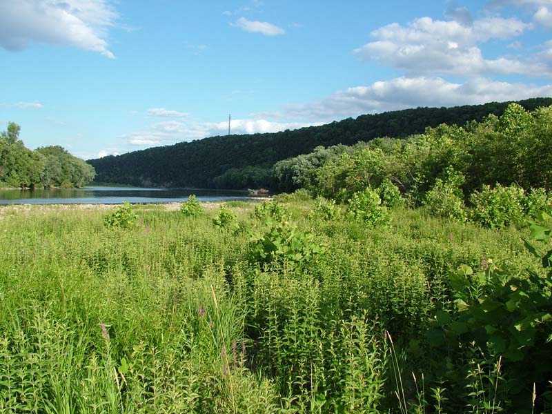
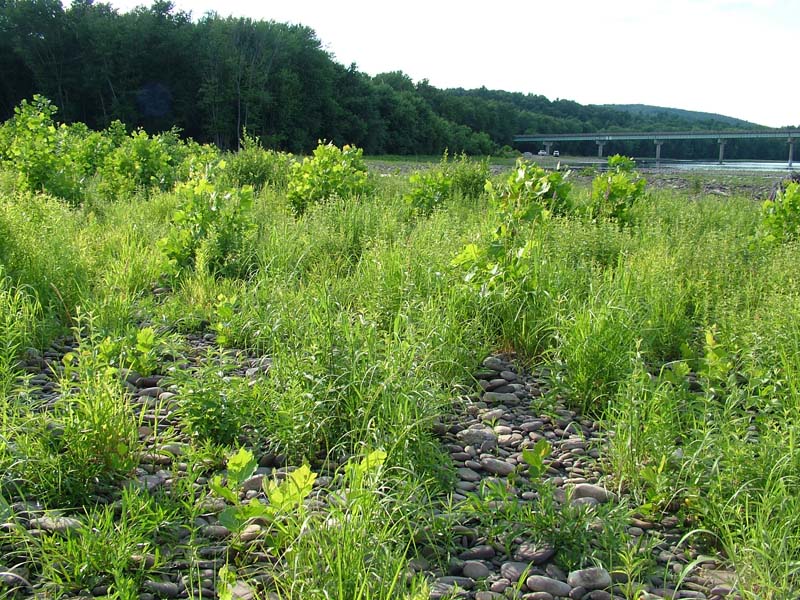
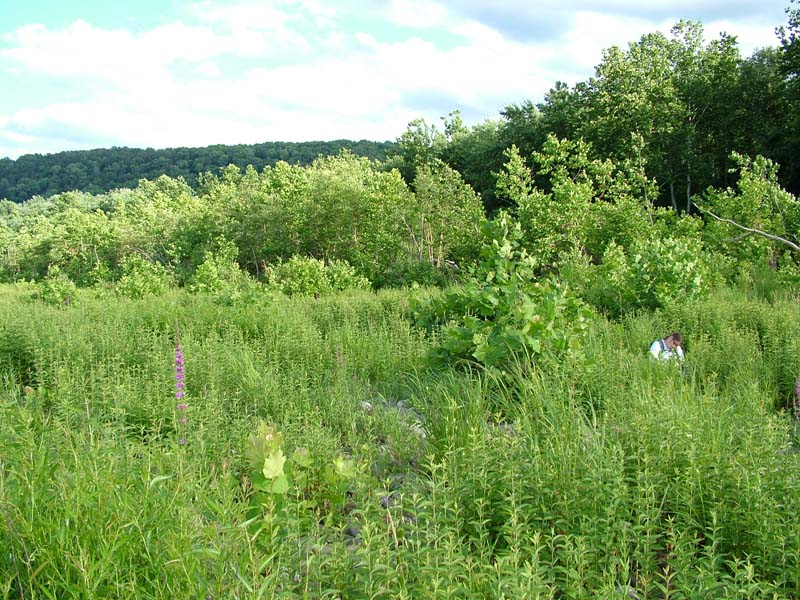
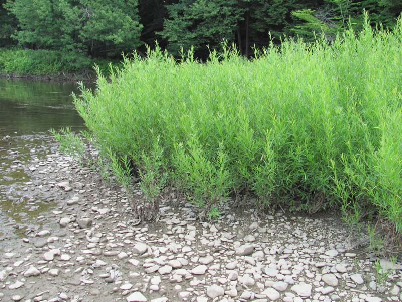
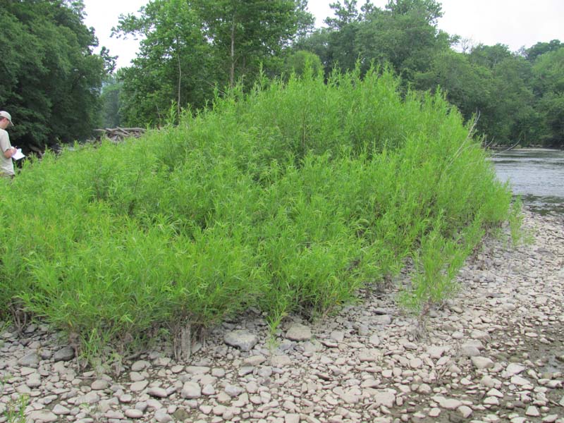
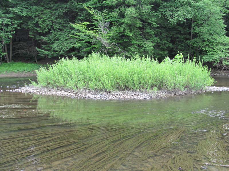
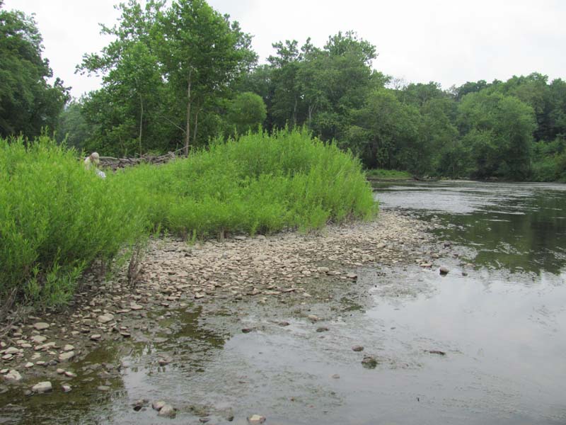
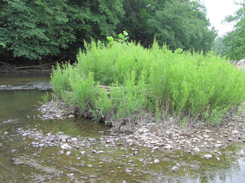
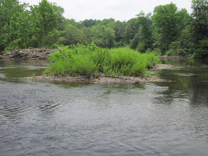
This community occurs on island heads and river bars,where the substrate is sand, sandy gravel, and/or cobbles. It typically occurs between the Periodically Exposed Shoreline Community and tall shrub communities or floodplain forest. These areas tend to be drier and droughty due to the elevation above the water and rapidly draining, coarse substrate. In times of high water , these areas are frequently inundated and subject to high stream velocity and ice scour. This community represents the transition between herbaceous- or graminoid-dominated areas that may be frequently stripped of vegetation and established shrublands from which the vegetation is rarely completely removed by river processes.
This community is characterized by a thick herbaceous and graminoid layer with scattered short shrubs (cover between 25-50%). Sandbar willow (Salix exigua) and black willow (Salix nigra) are typically the dominant short shrubs (<2 m in height), with occasional sycamore (Platanus occidentalis), silver maple (Acer saccharinum), box-elder (Acer negundo), steeplebush (Spiraea tomentosa), silky dogwood (Cornus amomum), and honey-locust (Gleditsia triacanthos). Scattered individuals of these same species may be present as tall shrubs (2-5 m in height). The scattered shrubs occur in a matrix of dense prairie grasses and forbs. The most common species include Indian-grass (Sorghastrum nutans), big bluestem (Andropogon gerardii), Indian-hemp (Apocynum cannabinum), pink dogbane (Apocynum androsaemifolium), garden loosestrife (Lysimachia vulgaris), water smartweed (Persicaria amphibia), smartweed (P. pensylvanica), reed canary-grass (Phalaris arundinacea), water-willow (Justicia americana), boneset (E. perfoliatum), white boneset (Eupatorium album), Joe-Pye-weed (Eutrochium fistulosum), and spotted spurge (Euphorbia maculata). Common vine species includes riverbank grape (Vitis riparia), which can be absent or moderately dense. This community is also susceptible to colonization by purple loosestrife (Lythrum salicaria).
Rank Justification
Vulnerable in the jurisdiction due to a restricted range, relatively few populations, recent and widespread declines, or other factors making it vulnerable to extirpation.
Identification
- Found on sand mixed with cobbles situated between the Periodically Exposed Shoreline and tall shrub communities or forest
- Dominated by warm season grasses, battered shrubs and trees comprising up to 50% of the cover
- Maintained by periodic high intensity flooding and ice scour
- Found in the Susquehanna and Delaware river basins in Pennsylvania
Shrubs
Herbs
- Indian-grass (Sorghastrum nutans)
- Big bluestem (Andropogon gerardii)
- Indian hemp (Apocynum cannabinum)
- Pink dogbane (Apocynum androsaemifolium)
- Water smartweed (Persicaria amphibia)
- Smartweed (Persicaria pensylvanica)
- Water-willow (Justicia americana)
- Boneset (Eupatorium perfoliatum)
- White-bracted eupatorium (Eupatorium album)
- Joe-pye-weed (Eutrochium fistulosum)
- Spotted spurge (Euphorbia maculata)
Exotic Species
* limited to sites with higher soil calcium
Vascular plant nomenclature follows Rhoads and Block (2007). Bryophyte nomenclature follows Crum and Anderson (1981).
International Vegetation Classification Associations:
USNVC Crosswalk:None
Representative Community Types:
Willow River-Bar Shrubland (CEGL006065)
Midwest Willow Sandbar Shrubland (CEGL005078)
NatureServe Ecological Systems:
Central Appalachian River Floodplain (CES202.608)
NatureServe Group Level:
None
Origin of Concept
Pennsylvania Natural Heritage Program. 2004. Classification, Assessment and Protection of Non-Forested Floodplain Wetlands of the Susquehanna Drainage. Report to: The United States Environmental Protection Agency and the Pennsylvania Department of Conservation and Natural Resources, Bureau of Forestry, Ecological Services Section. US EPA Wetlands Protection State Development Grant no. CD-98337501.
Pennsylvania Community Code*
HI : Big Bluestem – Indian Grass River Grassland
*(DCNR 1999, Stone 2006)
Similar Ecological Communities
Big Bluestem – Indian-grass Floodplain Grassland and Willow – Indian-grass Floodplain Shrub Wetland are similar in species composition and environmental setting. The main distinguishing feature between the two communities is that Willow – Indian-grass Floodplain Shrub Wetland has greater than 25% shrub cover.
Fike Crosswalk
None. This type is new to the Pennsylvania Plant Community Classification developed from river floodplain classification studies in the Susquehanna River Basin.
Conservation Value
Willow – Indian-grass Riverine Shrubland, while common, provides habitat for a number of important and rare insect species, namely tiger beetles (genus Cicindela), ground beetles (order Carabidae), and others during the drier periods of the year.
Threats
Alteration to the frequency and duration of flood events and development of the river floodplains are the two greatest threats to this community statewide and can lead to habitat destruction and/or shifts in community function and dynamics. Non-native invasive plants may be equally devastating as native floodplain plants are displaced. Development of adjacent land can lead to an accumulation of agricultural run-off, sedimentation, and pollution.
In addition, reed canary-grass (Phalaris arundinacea), Japanese knotweed (Fallopia japonica), giant knotweed (Fallopia sacchalinensis), and purple loosestrife (Lythrum salicaria) may invade sites supporting Willow – Indian-grass Riverine Shrubland; vulnerable sites tend to be those with deeper sand deposits. Construction of flood-control and navigational dams has resulted in drastic changes to the timing and duration of flood events. These dams have, in some cases, slowed the river flow resulting in deposition of finer sediments favored by the invasive plants.
Management
Direct impacts to the floodplain ecosystems (e.g., road construction, development, filling of wetlands) have greatly altered their composition, structure, and function region-wide. Further impacts that alter riparian function of the remaining areas should therefore be avoided. When development is unavoidable, low impact alternatives (e.g., elevated footpaths, boardwalks, bridges, pervious paving) that maintain floodplain processes should be utilized to minimize impacts to natural areas and the plant and animal species within them. Maintenance of natural buffers surrounding high quality examples of floodplain wetlands is recommended in order to minimize nutrient runoff, pollution, and sedimentation. Care should also be taken to control and prevent the spread of invasive species into high quality sites.
As floodplains are dependent on periodic disturbance, natural flooding frequency and duration should be maintained and construction of new dams, levees, or other in-stream modifications should be avoided. Activities resulting in destabilization of the banks or alteration of the disturbance patterns of the site should be avoided. Numerous land use planning recommendations have been proposed to reduce the negative impacts of changing land use on riparian systems. These include protecting riparian buffer habitat, retaining natural areas in developed landscapes, compensating for lost habitat, excluding livestock grazing from riparian areas, providing corridors between riparian and upland habitats, avoiding constructing roads and utility lines through riparian habitat areas, and restoring degraded riparian habitat. Providing the river system some scope to maintain itself may be more cost-effective in the long run than attempts at controlling natural functions through human intervention.
Research Needs
Variations may occur at ecoregional levels. There is a need to analyze plot data collected during floodplain studies to characterize variations of this community between different drainages. There is need to assess and quantify soils, site hydrology, and other factors to further assess differences between plant communities on floodplains supporting large patches of warm season grasses within the Ohio, Delaware, and Susquehanna river basins.
Trends
Willow – Indian-grass Floodplain Shrub Wetlands were undoubtedly more common along stretches of the large rivers in Pennsylvania. Construction of dam impoundments and conversion of these areas for human uses greatly impacted this type’s extent, resulting in occurrences only in the free flowing sections of the larger rivers. Alteration of the natural flooding regime (duration and frequency) has most likely been the most critical piece influencing the quality and persistence of this type. Barring construction of new flood-control and navigational dams, the relative trend for this community is likely stable. High quality examples are most likely declining with exotic species invasion.
Range Map
Pennsylvania Range
Large patches of this type are limited to free flowing sections of the Susquehanna and Upper Delaware rivers. Specifically, in the Susquehanna Basin, this community occurs along the North Branch, the West Branch, and the upper portions of the main stem of the Susquehanna River. It is also found within the upper portion of the Delaware River in Pennsylvania, New York, and New Jersey.
Global Distribution
Connecticut, Massachusetts, New Hampshire, New Jersey, New York, Pennsylvania, and Vermont.
Baker, M.E., and B.V. Barnes. 1998. Landscape ecosystem diversity of river floodplains in northwestern Lower Michigan, U.S.A. Canadian Journal of Forestry Research 28: 1405-1418.
Cowardin, L.M., V. Carter, F.C. Golet, and E.T. La Roe. 1979. Classification of wetlands and deepwater habitats of the United States. U.S. Fish and Wildlife Service. Washington, D.C. 131 pp.
Edinger, Gregory J., D.J. Evans, Shane Gebauer, Timothy G. Howard, David M. Hunt, and Adele M. Olivero. 2002. Ecological Communities of New York State. Second Edition. A revised and expanded edition of Carol Reschke's Ecological Communities of New York State. New York Natural Heritage Program, New York State Department of Environmental Conservation. Albany, NY. 136 pp.
Fike, J. 1999. Terrestrial and palustrine plant communities of Pennsylvania. Pennsylvania Natural Diversity Inventory. Harrisburg, PA. 86 pp.
Gregory, S.V., F.J. Swanson, W.A. McKee, and K.W. Cummins. 1991. An ecosystem perspective of riparian zones. Bioscience 41: 540-551.
NatureServe. 2009. International Ecological Classification Standard: International Vegetation Classification. Central Databases. NatureServe, Arlington, VA. Available http://www.natureserve.org/explorer.
Pennsylvania Department of Conservation and Natural Resources (DCNR). 1999. Inventory Manual of Procedure. For the Fourth State Forest Management Plan. Pennsylvania Bureau of Forestry, Division of Forest Advisory Service. Harrisburg, PA. 51 ppg.
Pennsylvania Natural Heritage Program. 2004. Classification, Assessment and Protection of Non-Forested Floodplain Wetlands of the Susquehanna Drainage. Report to: The United States Environmental Protection Agency and the Pennsylvania Department of Conservation and Natural Resources, Bureau of Forestry, Ecological Services Section. US EPA Wetlands Protection State Development Grant no. CD-98337501.
Stone, B., D. Gustafson, and B. Jones. 2006 (revised). Manual of Procedure for State Game Land Cover Typing. Commonwealth of Pennsylvania Game Commission, Bureau of Wildlife Habitat Management, Forest Inventory and Analysis Section, Forestry Division. Harrisburg, PA. 79 ppg.
Ward, J.V. 1998. Riverine landscapes: Biodiversity patterns, disturbance regimes, and aquatic conservation. Biological Conservation 83: 269-278.
Zimmerman, E., and G. Podniesinski. 2008. Classification, Assessment and Protection of
Floodplain Wetlands of the Ohio Drainage. Pennsylvania Natural Heritage Program, Western Pennsylvania Conservancy, Pittsburgh, PA. Report to: The United States Environmental Protection Agency and the Pennsylvania Department of Conservation and Natural Resources, Office of Conservation Science. US EPA Wetlands Protection State Development Grant no. CD-973081-01-0.
Cite as:
Zimmerman, E. 2022. Pennsylvania Natural Heritage Program. Willow – Indian-grass Floodplain Shrub Wetland Factsheet. Available from: https://www.naturalheritage.state.pa.us/community.aspx?=30022 Date Accessed: April 16, 2024


