Highbush Blueberry – Sphagnum Wetland
System: Palustrine
Subsystem: Shrubland
PA Ecological Group(s): Peatland Wetland
Global Rank:GNR
![]() rank interpretation
rank interpretation
State Rank: S5

General Description
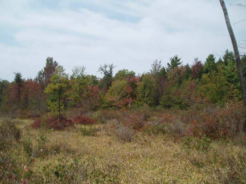
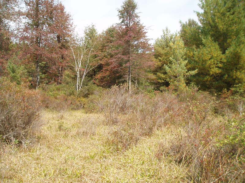
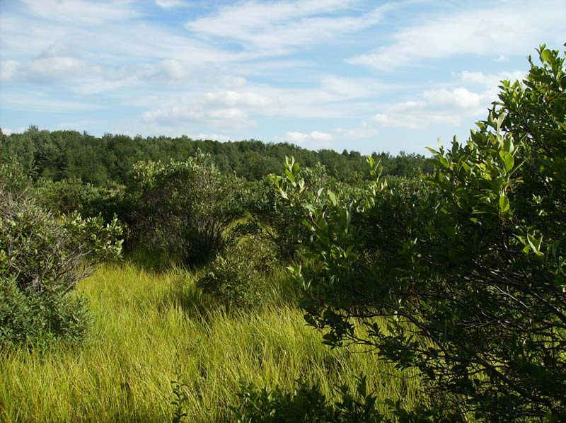
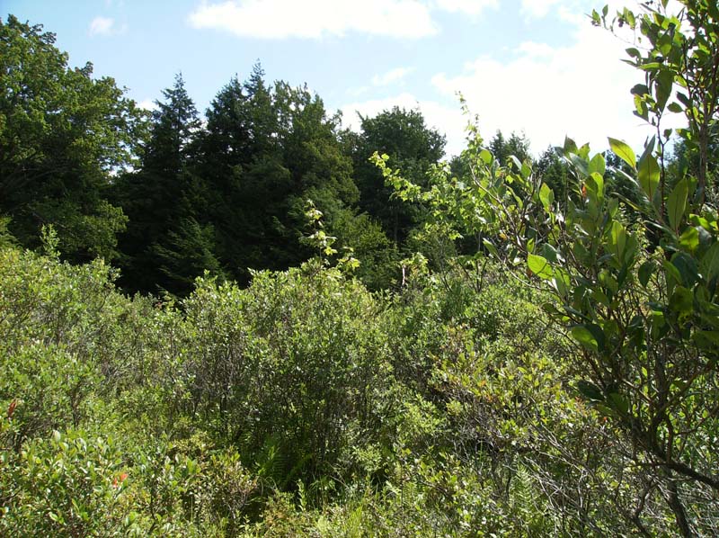
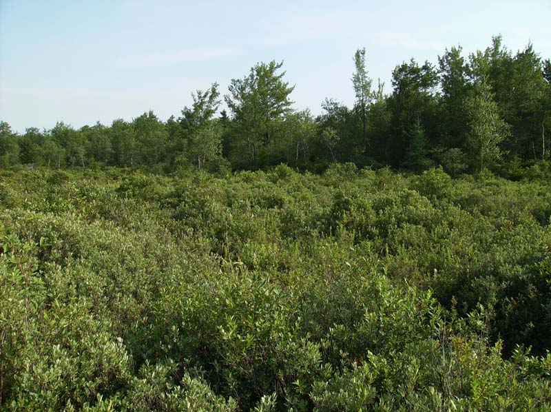
This community type generally occurs in shallow upland depressions (mostly in the glaciated regions of the state) or along the banks of slow moving acidic streams, or often as an intermediate zone between a structurally diverse wetland complex. It may also represent a successional phase, especially in beaver-influenced or otherwise impounded systems. Significant seasonal water level fluctuation can occur, especially in isolated basins without inlet or outlet streams. The substrate may be peat or mineral soil with a substantial accumulation of organic matter. The pH of this community is usually at the lower end of the pH spectrum as indicated by the presence of more acidophilic species.
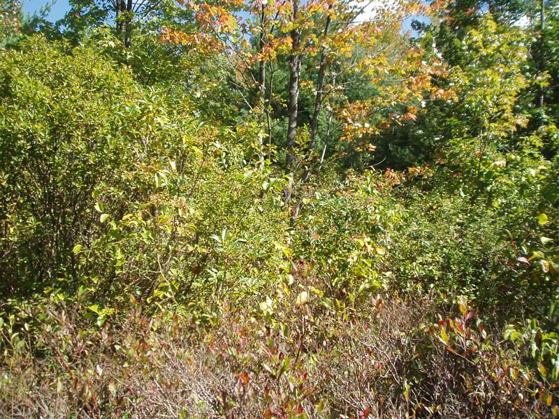
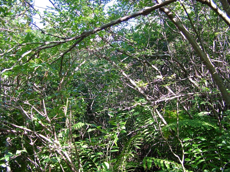
These communities are heath-dominated with a wide-spreading sphagnum layer beneath. This community type is characterized by a dense tall-shrub layer composed mostly of heath species. Highbush blueberry (Vaccinium corymbosum) is usually the dominant shrub species. Other shrubs commonly present include swamp azalea (Rhododendron viscosum), mountain holly (Ilex mucronata), leatherleaf (Chamaedaphne calyculata var. angustifolia), witherod (Viburnum cassinoides), and maleberry (Lyonia ligustrina). Seedlings or stunted red maple (Acer rubrum), gray birch (Betula populifolia), or other tree species may also be present at low densities. Sphagnum moss (Sphagnum spp.) blankets well-developed hummocks and hollows. The herbaceous layer is usually sparse and scattered over the sphagnum mat and is composed mostly of cinnamon fern (Osmunda cinnamomea), marsh fern (Thelypteris palustris), swamp dewberry (Rubus hispidus), and sedges (Carex sp.). This community may occur as part of the acidic glacial peatland complex.
Rank Justification
Common, widespread, and abundant in the jurisdiction.
Identification
- Occurs in shallow upland depressions (mostly in the glaciated regions of PA) or along the banks of slow moving acidic streams, or as an intermediate zone between a structurally diverse wetland complex
- Soils may be peat or mineral with a substantial accumulation of organic matter
- The pH of this community is acidic and is reflected in the vegetational composition
- The shrub layer is dominated by highbush blueberry (Vaccinium corymbosum) but other heath shrubs may also be present
- An extensive sphagnum layer is present
- The herbaceous layer is usually sparse and scattered
Shrubs
Herbs
Bryophytes
* limited to sites with higher soil calcium
Vascular plant nomenclature follows Rhoads and Block (2007). Bryophyte nomenclature follows Crum and Anderson (1981).
International Vegetation Classification Associations:
USNVC Crosswalk:None
Representative Community Types:
Highbush Blueberry Bog Thicket (CEGL006190)
Highbush Blueberry Poor Fen (CEGL005085)
NatureServe Ecological Systems:
North-Central Interior and Appalachian Acidic Peatland (CES202.606)
NatureServe Group Level:
None
Origin of Concept
Fike, J. 1999. Terrestrial and palustrine plant communities of Pennsylvania. Pennsylvania Natural Diversity Inventory. Pennsylvania Department of Conservation and Recreation, Bureau of Forestry, Harrisburg, PA. 86 pp.
Pennsylvania Community Code*
SG : Highbush Blueberry – Sphagnum Wetland
*(DCNR 1999, Stone 2006)
Similar Ecological Communities
The Highbush Blueberry – Meadow-sweet Wetland type is typically found in less acidic to circumneutral conditions. The Highbush Blueberry – Sphagnum Wetland is more characteristic of glaciated regions, is dominated by heaths such as swamp azalea (Rhododendron viscosum) and leatherleaf (Chamaedaphne calyculata var. angustifolia), and is often associated with larger peatland complexes, while the meadow-sweet type is more often found in upland depressions or areas of past impoundment.
Fike Crosswalk
Highbush Blueberry – Sphagnum Wetland
Conservation Value
Plant species of conservation concern found in this community may include marsh willow-herb (Epilobium palustre) and thread rush (Juncus filiformis). This community also serves as a buffer for sediment and pollution runoff from adjacent developed lands by slowing the flow of surficial water causing sediment to settle within this wetland.
Threats
Highbush Blueberry – Sphagnum Wetlands are threatened by habitat alteration (e.g., conversion to agricultural land, logging in adjacent uplands), deposition (e.g., sedimentation, nutrient loading), and alterations to the hydrological regime (e.g., removal of beaver dams or other impoundments, lowering of the water table). This habitat type may be exposed to limited foot traffic disturbance due to recreational fruit harvesting. Invasive species such as reed canary-grass (Phalaris arundinacea) may alter the species composition of this community type.
Management
Because Highbush Blueberry – Sphagnum Wetlands are relatively acidic and low in nutrients, they are susceptible to alteration by elevated nutrient inputs. This wetland may require larger buffers than other wetland types because of their high susceptibility to changes in nutrient concentrations.
A natural buffer around the wetland should be maintained in order to minimize nutrient runoff, pollution, and sedimentation. The potential for soil erosion based on soil texture, condition of the adjacent vegetation (mature forests vs. clearcuts), and the topography of the surrounding area (e.g., degree of slope) should be considered when establishing buffers. The buffer size should be increased if soils are erodible, adjacent vegetation has been logged, and the topography is steep as such factors could contribute to increased sedimentation and nutrient pollution. Direct impacts and habitat alteration should be avoided (e.g., roads, trails, filling of wetlands) and low impact alternatives (e.g., elevated footpaths, boardwalks, bridges) should be utilized in situations where accessing the wetland cannot be avoided. Care should also be taken to control and prevent the spread of invasive species within the wetland. Alterations to groundwater sources should be minimized.
Research Needs
Research is needed to fill information gaps about this community type, especially to advance our understanding of their classification, ecological processes, hydrology, floristic variation, development, and succession.
Trends
Wetland protection has most likely stabilized the decline of these communities. The relative trend for this community is most likely stable or may decline slightly due to hydrological alteration or ecological succession.
Range Map
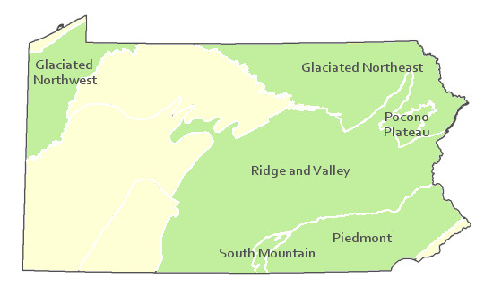
Pennsylvania Range
Glaciated Northeast, Glaciated Northwest, Pocono Plateau, Ridge and Valley, South Mountain, and possibly Piedmont.
Global Distribution
Connecticut, Maine, Massachusetts, New Hampshire, New Jersey New York, Pennsylvania, Rhode Island, and Vermount
Edinger, G.J., D.J. Evans, S. Gebauer, T.G. Howard, D.M. Hunt, and A. M. Olivero (editors). 2002. Ecological Communities of New York. Second Edition. A revised and expanded edition of Carol Reschke’s Ecological Communities of New York State. New York Natural Heritage Program, New York State department of Environmental Conservation. Albany, NY. 136pp.
Fike, J. 1999. Terrestrial and palustrine plant communities of Pennsylvania. Pennsylvania Natural Diversity Inventory. Harrisburg, PA 79 pp.
NatureServe. 2005. NatureServe Central Databases. Arlington, Virginia. USA.
Pennsylvania Department of Conservation and Natural Resources (DCNR). 1999. Inventory Manual of Procedure. For the Fourth State Forest Management Plan. Pennsylvania Bureau of Forestry, Division of Forest Advisory Service. Harrisburg, PA. 51 ppg.
Perles, S.J., G.S. Podniesinski, E. Eastman, L.A. Sneddon, and S.C. Gawler. 2007. Classification and mapping of vegetation and fire fuel models at Delaware Water Gap National Recreation Area: Volume 2 of 2 – Appendix G. Technical Report NPS/NER/NRTR – 2007/076. National Park Service. Philadelphia, PA.
Rhoads, Ann F. and Timothy A. Block. 1999. Natural Areas Inventory of Bucks County, Pennsylvania. Bucks County Commissioners, Doylestown, PA.
Rhoads, Ann F. and Timothy A. Block. 2002. Survey of Natural Areas of Hickory Run State Park. Report submitted to DCNR, Bureau of State Parks.
Rhoads, Ann F. and Timothy A. Block. 2002. Tobyhanna State Park Natural Areas Survey. Report submitted to DCNR, Bureau of State Parks.
Rhoads, Ann F. and Timothy A. Block. 2006. Vegetation Inventory of Gouldsboro State Park. Report submitted to DCNR, Bureau of State Parks.
Stone, B., D. Gustafson, and B. Jones. 2006 (revised). Manual of Procedure for State Game Land Cover Typing. Commonwealth of Pennsylvania Game Commission, Bureau of Wildlife Habitat Management, Forest Inventory and Analysis Section, Forestry Division. Harrisburg, PA. 79 ppg.
Cite as:
Furedi, M. 2022. Pennsylvania Natural Heritage Program. Highbush Blueberry – Sphagnum Wetland Factsheet. Available from: https://www.naturalheritage.state.pa.us/Community.aspx?=16035 Date Accessed: January 13, 2026


