Pickerel-weed – Arrow-arum – Arrowhead Emergent Wetland
System: Palustrine
Subsystem: Non-persistent
PA Ecological Group(s): Emergent Wetland and Marsh Wetland
Global Rank:GNR
![]() rank interpretation
rank interpretation
State Rank: S4
General Description
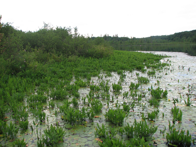
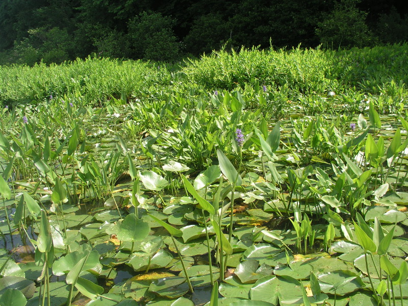
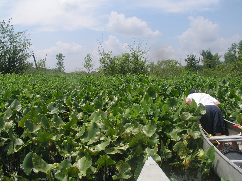
This community type is dominated by broad-leafed, emergent vegetation; it occurs in upland depressions, borders of lakes, large slow-moving rivers, and shallow ponds. The aspect of these systems changes seasonally from nearly unvegetated substrate in winter and early spring, when plants are dormant, to dense vegetation during the height of the growing season. The most characteristic species are pickerel-weed (Pontederia cordata), arrow-arum (Peltandra virginica), and wapato (Sagittaria latifolia). Other species commonly present include showy bur-marigold (Bidens laevis), mannagrass (Glyceria spp.), goldenclub (Orontium aquaticum), bur-reed (Sparganium spp), arrowhead (Sagittaria rigida), soft-stem bulrush (Schoenoplectus tabernaemontani), spike-rush (Eleocharis palustris), false water-pepper (Persicaria hydropiperoides), water-pepper (Persicaria punctata), water smartweed (Persicaria amphibia), jewelweed (Impatiens spp.), common bladderwort (Utricularia macrorhiza), duckweed (Lemna minor), water-meal (Wolffia spp.), and broad-leaved water-plantain (Alisma subcordatum). This community is often interweaved with aquatic beds on the deep side, and shallower marsh or swamp communities on the shore side, and thus species characteristic of those communities are often present. This type is restricted to shallow (less than 2 meters at low water) depressions, or the edges of lakes, ponds, and rivers.
Rank Justification
Uncommon but not rare; some cause for long-term concern due to declines or other factors.
Identification
- Emergent marsh dominated by broad-leaved, aerenchymatous plants filling small depressions, as well as along pondshores, lakeshores, impoundments, and quiet riverbanks
- Occurs in perennial standing water up to about a meter deep
- Usually develops muck soils over a sand or gravel substrate
- Typical species include pickerel-weed (Pontederia cordata), arrow-arum (Peltandra virginica), and wapato (Sagittaria latifolia)
Herbs
- Pickerel-weed (Pontederia cordata)
- Arrow-arum (Peltandra virginica)
- Wapato (Sagittaria latifolia)
- Showy bur-marigold (Bidens laevis)
- Mannagrass (Glyceria spp.)
- Goldenclub (Orontium aquaticum)
- Arrowhead (Sagittaria rigida)
- Soft-stemmed bulrush (Schoenoplectus tabernaemontani)
- Creeping spike-rush (Eleocharis palustris)
- Mild water-pepper (Persicaria hydropiperoides)
- Dotted smartweed (Persicaria punctata)
- Jewelweed (Impatiens spp.)
- Broad-leaved water-plantain (Alisma subcordatum)
- Common bladderwort (Utricularia macrorhiza)
- Duckweed (Lemna minor)
- Water smartweed (Persicaria amphibia)
- Lizard's-tail (Saururus cernuus)
- Water-hemlock (Cicuta bulbifera)
Exotic Species
* limited to sites with higher soil calcium
Vascular plant nomenclature follows Rhoads and Block (2007). Bryophyte nomenclature follows Crum and Anderson (1981).
International Vegetation Classification Associations:
USNVC Crosswalk:None
Representative Community Types:
Northeastern Leafy Forb Marsh (CEGL006191)
NatureServe Ecological Systems:
Laurentian-Acadian Freshwater Marsh (CES201.594)
NatureServe Group Level:
None
Origin of Concept
Fike, J. 1999. Terrestrial and palustrine plant communities of Pennsylvania. Pennsylvania Natural Diversity Inventory. Pennsylvania Department of Conservation and Recreation, Bureau of Forestry, Harrisburg, PA. 86 pp.
Pennsylvania Community Code*
HA : Pickerel-Weed – Arrow-Arum – Arrowhead Wetland
*(DCNR 1999, Stone 2006)
Similar Ecological Communities
Some examples of the Wool-grass – Mannagrass – Mixed Shrub Vernal Pool community type may resemble this floristically. The two differ in their hydrologic regime; the vernal pool type occurs in small upland depressions that are seasonally flooded, but experience substantial or complete annual draw-down. Pickerel-weed – Arrow-arum – Arrowhead Emergent Wetland is usually permanently to semi-permanently flooded. Spatterdock – Water-lily Emergent Wetland may occur intermingled with or surrounded by the Pickerel-weed – Arrow-arum – Arrowhead Emergent Wetland. These two types may intergrade but the Spatterdock – Water-lily Emergent Wetland represents a wetland comprised of floating aquatic vegetation dominated by spatterdock (Nuphar advena/ N. variegata) and fragrant water-lily (Nymphaea odorata)), where as the Pickerel-weed – Arrow-arum – Arrowhead Emergent Wetland is often classified as a broad-leaved emergent wetland.
Fike Crosswalk
Pickerel-weed - arrow-arum - arrowhead wetland
Conservation Value
Pickerel-weed – Arrow-arum – Arrowhead Emergent Wetland can serve as habitat for rare marsh birds and odonates as well as provide cover for small fish, reptiles, and amphibians. Rare plant species such as hard-stem bulrush (Schoenoplectus acutus), river bulrush (Schoenoplectus fluviatilis), and water bulrush (Schoenoplectus subterminalis) may be present within this community. This community also serves as a buffer for sediment and pollution runoff from adjacent developed lands by slowing the flow of surficial water causing sediment to settle within this wetland.
Threats
Alteration to the hydrological regime is a major threat to this community (e.g., impoundments, beaver dams) and can lead to habitat destruction and/or shifts in community function and dynamics. Clearing and development of adjacent land can lead to an accumulation of agricultural run-off and pollution, sedimentation, and insolation/thermal pollution. Purple loosestrife (Lythrum salicaria) can be an exotic plant species that invades this community and displaces native species.
Management
A natural buffer around the wetland should be maintained in order to minimize nutrient runoff, pollution, and sedimentation. The potential for soil erosion based on soil texture, condition of the adjacent vegetation (mature forests vs. clearcuts), and the topography of the surrounding area (i.e., degree of slope) should be considered when establishing buffers. The buffer size should be increased if soils are erodible, adjacent vegetation has been logged, and the topography is steep, as such factors could contribute to increased sedimentation and nutrient pollution. Direct impacts and habitat alteration should be avoided (e.g., roads, trails, filling of wetlands) and low impact alternatives (e.g., elevated footpaths, boardwalks, bridges) should be utilized in situations where accessing the wetland can not be avoided. Care should also be taken to control and prevent the spread of invasive species within the wetland.
Research Needs
There is a need to collect plot data to characterize variations and guide further classification of this community.
Trends
While it is true that naturally occurring wetlands have most likely declined due to wetland draining/filling activities and clearing of the adjacent lands, the construction of dams and artificial reservoirs, lakes and ponds has probably resulted a greater number of emergent Pickerel-weed – Arrow-arum – Arrowhead Emergent Wetlands than were present historically. The relative trend for this community is likely stable.
Range Map
Pennsylvania Range
Glaciated NE, Glaciated NW, Ridge and Valley, Piedmont.
Global Distribution
Connecticut, Maine, Massachusetts, New Hampshire, New Jersey, New York, Pennsylvania, Rhode Island, and Vermont.
Cowardin, L. M., V. Carter, F. C. Golet, and E. T. LaRoe. 1979. Classification of wetlands and deepwater habitats of the United States. U.S. Fish and Wildlife Service, Biological Service Program. FWS/OBS-79/31. Washington, DC. 103 pp.
Eastern Ecology Working Group of NatureServe. No date. International Ecological Classification Standard: International Vegetation Classification. Terrestrial Vegetation. NatureServe, Boston, MA.
Edinger, G. J., D. J. Evans, S. Gebauer, T. G. Howard, D. M. Hunt, and A. M. Olivero, editors. 2002. Ecological communities of New York state. Second edition. A revised and expanded edition of Carol Reschke's ecological communities of New York state. (Draft for review). New York Natural Heritage Program, New York State Department of Environmental Conservation, Albany, NY.
Fike, J. 1999. Terrestrial and palustrine plant communities of Pennsylvania. Pennsylvania Natural Diversity Inventory. Pennsylvania Department of Conservation and Recreation. Bureau of Forestry. Harrisburg, PA. 86 pp.
Gawler, S. C. 2002. Natural landscapes of Maine: A guide to vegetated natural communities and ecosystems. Maine Natural Areas Program, Department of Conservation, Augusta, ME. [in press]
Metzler, K. J., and J. P. Barrett. 2001. Vegetation classification for Connecticut. Draft 5/21/2001. Connecticut Department of Environmental Protection, Natural Resources Center, Natural Diversity Database, Hartford.
NatureServe 2010. NatureServe Explorer: An online encyclopedia of life Version 7.1. NatureServe, Arlington, VA. Available http://www.natureserv.org/explorer (accessed: 23 November 2011).
NRCS [Natural Resources Conservation Service]. 2004. Soil survey of Saratoga County, New York. USDA Natural Resources Conservation Service. 590 pp.
Pennsylvania Department of Conservation and Natural Resources (DCNR). 1999. Inventory Manual of Procedure. For the Fourth State Forest Management Plan. Pennsylvania Bureau of Forestry, Division of Forest Advisory Service. Harrisburg, PA. 51 ppg.
Rawinski, T. 1984. Natural community description abstract - southern New England calcareous seepage swamp. Unpublished report. The Nature Conservancy, Boston, MA. 6 pp.
Rhoads, Ann F. and Timothy A. Block. 1999. Natural Areas Inventory of Bucks County, Pennsylvania. Bucks County Commissioners, Doylestown, PA.
Sperduto, D. D. 2000a. Natural communities of New Hampshire: A guide and classification. Near final unformatted draft without pictures and illustrations; includes upland classification. New Hampshire Natural Heritage Inventory, DRED Division of Forests and Lands, Concord, NH. 127 pp.
Stone, B., D. Gustafson, and B. Jones. 2006 (revised). Manual of Procedure for State Game Land Cover Typing. Commonwealth of Pennsylvania Game Commission, Bureau of Wildlife Habitat Management, Forest Inventory and Analysis Section, Forestry Division. Harrisburg, PA. 79 ppg.
Swain, P. C., and J. B. Kearsley. 2000. Classification of natural communities of Massachusetts. July 2000 draft. Natural Heritage and Endangered Species Program, Massachusetts Division of Fisheries and Wildlife. Westborough, MA.
Thompson, E. 1996. Natural communities of Vermont uplands and wetland. Nongame and Natural Heritage Program, Department of Fish and Wildlife in cooperation with The Nature Conservancy, Vermont chapter. 34 pp.
Thompson, E. H., and E. R. Sorenson. 2000. Wetland, woodland, wildland: A guide to the natural communities of Vermont. The Nature Conservancy and the Vermont Department of Fish and Wildlife. University Press of New England, Hanover, NH. 456 pp.
Cite as:
Eichelberger, B. 2022. Pennsylvania Natural Heritage Program. Pickerel-weed – Arrow-arum – Arrowhead Emergent Wetland Factsheet. Available from: https://www.naturalheritage.state.pa.us/Community.aspx?=15994 Date Accessed: June 23, 2026


