Floodplain Scour Community
System: Palustrine
Subsystem: Sparse Vegetation
PA Ecological Group(s): River Floodplain and Sparse Vegetation
Global Rank:GNR
![]() rank interpretation
rank interpretation
State Rank: S1S2
General Description
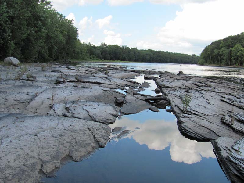
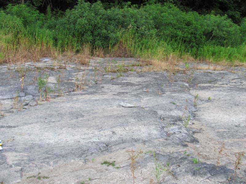
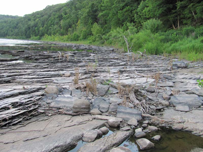
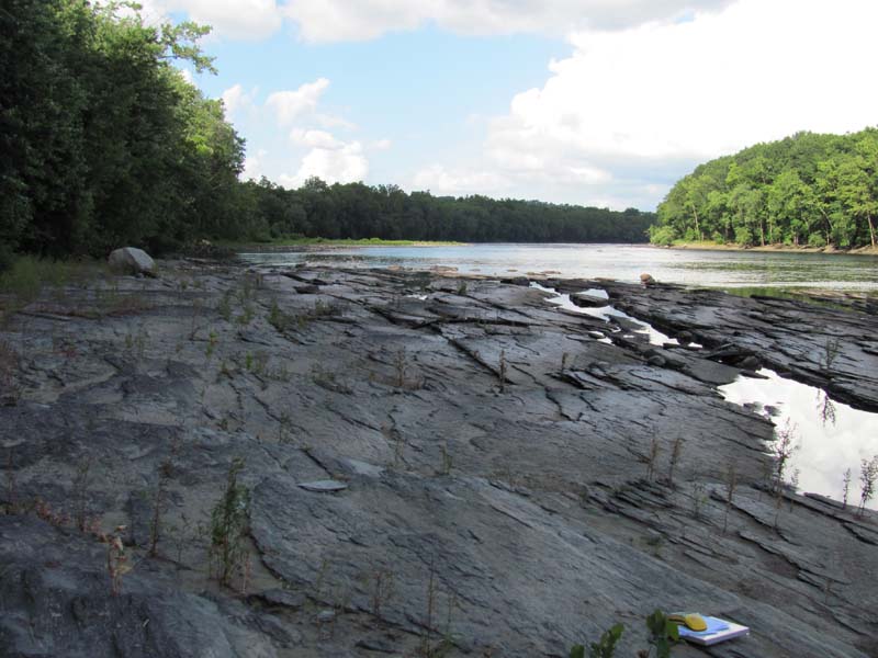
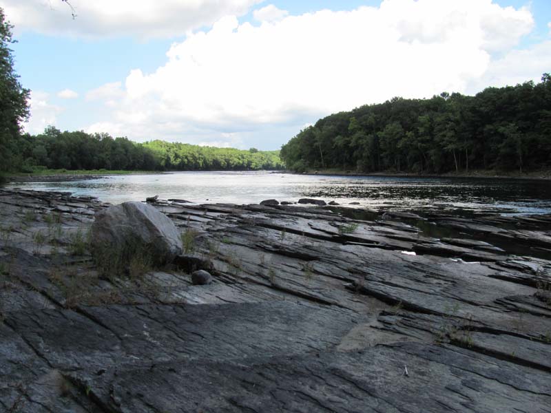
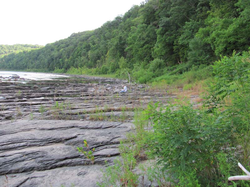
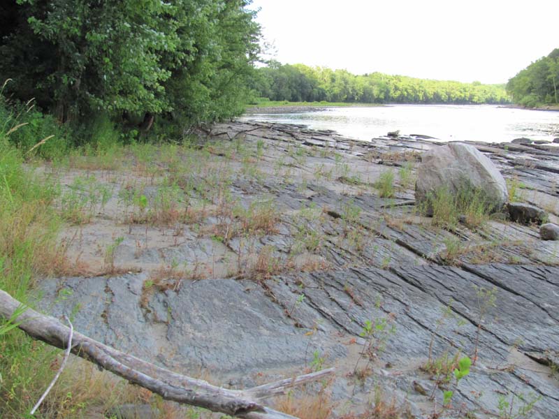
This community type occurs along the banks of major rivers where rock outcrops are subject to winter ice scour and high-velocity flooding. The term scour suggests removal of soil and plants, but most of this material is deposited locally rather than being washed downstream away from the scoured portion of the river. The result is an alteration of scour and deposition spatially, and sometimes temporally, within a small area along the banks of the river. Plants grow in soil that accumulates in cracks in the rock. The community shares ecological characteristics with river banks, floodplains, wetlands and prairies. This combination of conditions leads to a unique grouping of species generally associated with one or more of those ecosystems. Trees, including sycamore (Platanus occidentalis), silver maple (Acer saccharinum), and river birch (Betula nigra), are often contorted and battered and are limited in growth by the high velocity of the floodwaters and ice. Common shrub species include willows (Salix spp.), wild hydrangea (Hydrangea arborescens), smooth azalea (Rhododendron arborescens), swamp azalea (R. viscosum), rosebay (R. maximum), buttonbush (Cephalanthus occidentalis), swamp rose (Rosa palustris), and ninebark (Physocarpus opulifolius). Herbaceous plants include Indian-grass (Sorghastrum nutans), big bluestem (Andropogon gerardii), cordgrass (Spartina pectinata), indian hemp (Apocynum cannabinum), great St. John’s-wort (Hypericum pyramidatum), pale St. John’s-wort (H. ellipticum), dwarf St. John’s-wort (H. mutilum), false-indigo (Amorpha fruticosa), royal fern (Osmunda regalis), Joe-Pye weed (Eutrochium spp.), reed canary-grass (Phalaris arundinacea), groundsel (Packera spp.), and golden Alexanders (Zizia aurea). Vines include poison ivy (Toxicodendron radicans) and grapes (Vitis spp.).
Several rare species are found in this community including Barbara’s-buttons (Marshallia grandiflora), sand grape (Vitis rupestris), Carolina tassel-rue (Trautvetteria caroliniensis), stiff-leaved aster (Ionactis linariifolius), umbrella-tree (Magnolia tripetala), cowbane (Oxypolis rigidior), aster-like boltonia (Boltonia asteroides), bushy St. John’s-wort (Hypericum densiflorum), sand cherry (Prunus pumila var. depressa), arrow-feather (Aristida purpurascens), halberd-leaved rose-mallow (Hibiscus laevis), Chamisso’s miners-lettuce (Montia chamissoi), and Virginia mallow (Sida hermaphrodita).
Rank Justification
Imperiled in the jurisdiction because of rarity due to very restricted range, very few populations, steep declines, or other factors making it very vulnerable to extirpation from jurisdiction.
Identification
- Sparse to dense vegetation growing amidst large expances of exposed bedrock, boulders, or cobble substrate
- Plants grow in soil that accumulates in cracks in the rock
- Various warm season grasses, ferns, and herbaceous species with scattered, often battered shrubs and trees
- Maintained by annual episodes of high intensity flooding and ice scour
Shrubs
- Sycamore (Platanus occidentalis)
- Silver maple (Acer saccharinum)
- River birch (Betula nigra)
- Willows (Salix spp.)
- Wild hydrangea (Hydrangea arborescens)
- Smooth azalea (Rhododendron arborescens)
- Rosebay (Rhododendron maximum)
- Swamp azalea (Rhododendron viscosum)
- Ninebark (Physocarpus opulifolius)
- Buttonbush (Cephalanthus occidentalis)
- Swamp rose (Rosa palustris)
Herbs
- Indian-grass (Sorghastrum nutans)
- Big bluestem (Andropogon gerardii)
- Freshwater cordgrass (Spartina pectinata)
- Indian hemp (Apocynum cannabinum)
- Great St. John's-wort (Hypericum pyramidatum)
- Pale St. John's-wort (Hypericum ellipticum)
- Dwarf St. John's-wort (Hypericum mutilum)
- False-indigo (Amorpha fruticosa)
- Royal fern (Osmunda regalis)
- Sensitive fern (Onoclea sensibilis)
- Joe-pye-weed (Eutrochium spp.)
- Reed canary-grass (Phalaris arundinacea)
- Groundsel (Packera spp.)
- Golden-alexander (Zizia aurea)
- Barbara's-buttons (Marshallia grandiflora)
- Aster-like boltonia (Boltonia asteroides)
- Carolina tassel-rue (Trautvetteria caroliniensis)
- Bushy St. John's-wort (Hypericum densiflorum)
- Sand cherry (Prunus pumila var. depressa)
- Arrow-feather (Aristida purpurascens)
- Halberd-leaved rose-mallow (Hibiscus laevis)
- Chamisso's miner's-lettuce (Montia chamissoi)
- Virginia mallow (Sida hermaphrodita)
Vines
* limited to sites with higher soil calcium
Vascular plant nomenclature follows Rhoads and Block (2007). Bryophyte nomenclature follows Crum and Anderson (1981).
International Vegetation Classification Associations:
USNVC Crosswalk:
Floodplain Scour Community (CEGL006623)
Northern Riverside Rock Outcrop (CEGL006284)
Barbara's-buttons Riverscour Prairie (CEGL006598)
NatureServe Ecological Systems:
Central Appalachian River Floodplain (CES202.608)
NatureServe Group Level:
None
Origin of Concept
Zimmmerman 2008, PNHP 2010. Natural Resources Inventory and Management Recommendations for Ohiopyle State Park.Report to Bureau of State Parks
Pennsylvania Department of Conservation and Natural Resources. Pittsburgh, PA
Pennsylvania Community Code*
HD : Riverside Ice Scour Community
*(DCNR 1999, Stone 2006)
Similar Ecological Communities
Big Bluestem – Indian-grass Floodplain Grassland and Willow – Indian-grass Floodplain Shrub Wetland share many species and a prairie-like appearance with the Floodplain Scour Community. Both may be dominated by tall, warm season grasses and species common to tall grass prairies of the upper Midwest. However the Floodplain Scour Community is distinguished from the grassland type by the site hydrology and substrate. Floodplain Scour Community patches are typically smaller than the Big Bluestem – Indian-grass Floodplain Grassland and Willow – Indian-grass Floodplain Shrub Wetland and are primarily found in association with outcrops of bedrock or large boulders and are subject to winter ice scour and catastrophic, annual flooding. The Floodplain Scour Community patches are generally less-vegetated than the Big Bluestem – Indian-grass Floodplain Grassland, as plants grow in the soil that accumulates between large boulders and cracks in the bedrock. The Periodically Exposed Shoreline Community community patches are more widespread and contain a wider variety of plant species, often non-native plants, and generally lack the warm season grasses, royal fern, and shrub species. The substrate underlying the Periodically Exposed Shoreline Community community is variable, most often alluvial deposits, including sand, silt, and gravel and rarely is composed of consolidated boulders or bedrock, which characterizes the substrate of most Floodplain Scour Community patches.
Fike Crosswalk
Riverside Ice Scour Communitiy
Conservation Value
The scour community is an important part of the river floodplain ecosystem and is rare in the state, occurring only along free flowing portions of larger rivers. Several rare species are found in this community in different parts of the state including Barbara’s-buttons (Marshallia grandiflora), sand grape (Vitis rupestris), Carolina tassel-rue (Trautvetteria caroliniensis), stiff-leaved aster (Ionactis linariifolius), umbrella-tree (Magnolia tripetala), cowbane (Oxypolis rigidior), aster-like boltonia (Boltonia asteroides), bushy St. John’s-wort (Hypericum densiflorum), sand cherry (Prunus pumila var. depressa), arrow-feather (Aristida purpurascens), halberd-leaved rose-mallow (Hibiscus laevis), Chamisso’s miners-lettuce (Montia chamissoi), and Virginia mallow (Sida hermaphrodita).
This type shares ecological characteristics with river banks, floodplains, wetlands, and prairies. The combination of conditions leads to a unique grouping of species generally associated with one or more of those ecosystems. Several rare dragonflies and damselflies use the open habitat for basking and hunting. Northern water snakes (Nerodia sipedon) and copperhead snakes (Agkistrodon contortrix) use this community for basking areas. Birds that use the Floodplain Scour Community are common yellowthroats (Geothlypis trichas), song sparrows (Melospiza melodia), rufous-sided towhees (Pipilo erythrophthalmus), and spotted sandpipers (Actitis macularia).
Threats
Alteration to the frequency and duration of flood events and development of the river floodplains are the two greatest threats to this community statewide and can lead to habitat destruction and/or shifts in community function and dynamics. Non-native invasive plants may be equally devastating as native floodplain plants are displaced. Development of adjacent land can lead to an accumulation of agricultural run-off, sedimentation, and pollution.
In addition, reed canary-grass (Phalaris arundinacea), Japanese knotweed (Fallopia japonica), giant knotweed (F. sachalinensis), and purple loosestrife (Lythrum salicaria) may invade sites supporting the Floodplain Scour Community; vulnerable sites tend to be those with deeper sand deposits. Construction of flood-control and navigational dams has resulted in drastic changes to the timing and duration of flood events. These dams have, in some cases, slowed the river flow resulting in deposition of finer sediments favored by the invasive plants.
Management
Direct impacts to the floodplain ecosystems (e.g., road construction, development, filling of wetlands) have greatly altered plant community composition, structure, and function of floodplain communities region-wide. Further impacts that alter riparian function of the remaining areas should therefore be avoided. Protection of the river scour plants, often growing in cracks, depressions, and behind rocks, where sand and sediment accumulates is important for sustaining the species that make up this community. Concentrating recreational activity to designated areas (i.e., well marked trails and fishing areas) can greatly reduce impact to sensitive plant species. Maintenance of natural buffers surrounding high quality examples of River Scour is recommended in order to minimize nutrient runoff, pollution, and sedimentation. Care should also be taken to control and prevent the spread of invasive species into high quality sites.
As River Scour communities are dependent on periodic disturbance, natural flooding frequency and duration should be maintained and construction of new dams, levees, or other in-stream modifications should be avoided. Numerous land use planning recommendations have been proposed to reduce the negative impacts of changing land use on riparian systems. These include protecting riparian buffer habitat, retaining natural areas in developed landscapes, compensating for lost habitat, excluding livestock grazing from riparian areas, providing corridors between riparian and upland habitats, avoiding constructing roads and utility lines through riparian habitat areas, and restoring degraded riparian habitat. Providing the river system some scope to maintain itself may be more cost-effective in the long run than attempts at controlling natural functions through human intervention.
Research Needs
Variations may occur at ecoregional levels. There is a need to assess and quantify soils, site hydrology, disturbance frequency, and other factors to further assess differences between scour habitats on the Ohio, Delaware, and Susquehanna river basins. There is need to monitor high quality examples of this community type.
Trends
Floodplain Scour Community patches are most likely declining due to destruction of plant populations or alteration of ecosystem processes needed to maintain populations. Construction of dam impoundments and conversion of these once expansive areas for human uses greatly impacted the plant composition of this type as alteration of the natural flooding regime (duration and frequency) is the most critical piece maintaining the quality and persistence of this type. High quality examples are most likely declining with exotic species invasion, human impacts (trampling), and alteration to natural disturbance regimes.
Range Map
Pennsylvania Range
Statewide
Global Distribution
Connecticut, Maine, Massachusetts, New Hampshire, New Jersey, New York, Pennsylvania, and Vermont
Baker, M.E., and B.V. Barnes. 1998. Landscape ecosystem diversity of river floodplains in northwestern Lower Michigan, U.S.A. Canadian Journal of Forestry Research 28: 1405-1418.
Cowardin, L.M., V. Carter, F.C. Golet, and E.T. La Roe. 1979. Classification of wetlands and deepwater habitats of the United States. U.S. Fish and Wildlife Service. Washington, D.C. 131 pp.
Edinger, Gregory J., D.J. Evans, Shane Gebauer, Timothy G. Howard, David M. Hunt, and Adele M. Olivero. 2002. Ecological Communities of New York State. Second Edition. A revised and expanded edition of Carol Reschke's Ecological Communities of New York State. New York Natural Heritage Program, New York State Department of Environmental Conservation. Albany, NY. 136 pp.
Fike, J. 1999. Terrestrial and palustrine plant communities of Pennsylvania. Pennsylvania Natural Diversity Inventory. Harrisburg, PA. 86 pp.
Gregory, S.V., F.J. Swanson, W.A. McKee, and K.W. Cummins. 1991. An ecosystem perspective of riparian zones. Bioscience 41: 540-551.
NatureServe. 2009. International Ecological Classification Standard: International Vegetation Classification. Central Databases. NatureServe, Arlington, VA. Available http://www.natureserve.org/explorer.
NatureServe. 2009. NatureServe Central Databases. Arlington, Virginia. USA
Pennsylvania Department of Conservation and Natural Resources (DCNR). 1999. Inventory Manual of Procedure. For the Fourth State Forest Management Plan. Pennsylvania Bureau of Forestry, Division of Forest Advisory Service. Harrisburg, PA. 51 ppg.
Pennsylvania Natural Heritage Program. 2004. Classification, Assessment and Protection of Non-Forested Floodplain Wetlands of the Susquehanna Drainage. Report to: The United States Environmental Protection Agency and the Pennsylvania Department of Conservation and Natural Resources, Bureau of Forestry, Ecological Services Section. US EPA Wetlands Protection State Development Grant no. CD-98337501.
Stone, B., D. Gustafson, and B. Jones. 2006 (revised). Manual of Procedure for State Game Land Cover Typing. Commonwealth of Pennsylvania Game Commission, Bureau of Wildlife Habitat Management, Forest Inventory and Analysis Section, Forestry Division. Harrisburg, PA. 79 ppg.
Ward, J.V. 1998. Riverine landscapes: Biodiversity patterns, disturbance regimes, and aquatic conservation. Biological Conservation 83: 269-278.
Zimmerman, E., and G. Podniesinski. 2008. Classification, Assessment and Protection of
Floodplain Wetlands of the Ohio Drainage. Pennsylvania Natural Heritage Program, Western Pennsylvania Conservancy, Pittsburgh, PA. Report to: The United States Environmental Protection Agency and the Pennsylvania Department of Conservation and Natural Resources, Office of Conservation Science. US EPA Wetlands Protection State Development Grant no. CD-973081-01-0.
Cite as:
Zimmmerman 2022. Pennsylvania Natural Heritage Program. Floodplain Scour Community Factsheet. Available from: https://www.naturalheritage.state.pa.us/Community.aspx?=16011 Date Accessed: July 28, 2026


