Oak – Mixed Hardwood Palustrine Forest
System: Palustrine
Subsystem: Forest
PA Ecological Group(s):
River Floodplain and Basin Wetland and Vernal Pool
Global Rank:GNR
![]() rank interpretation
rank interpretation
State Rank: S2
General Description
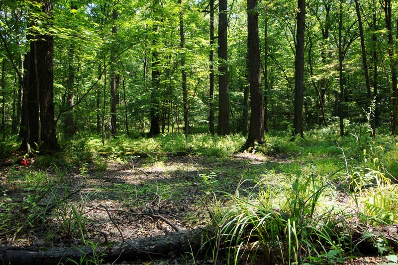
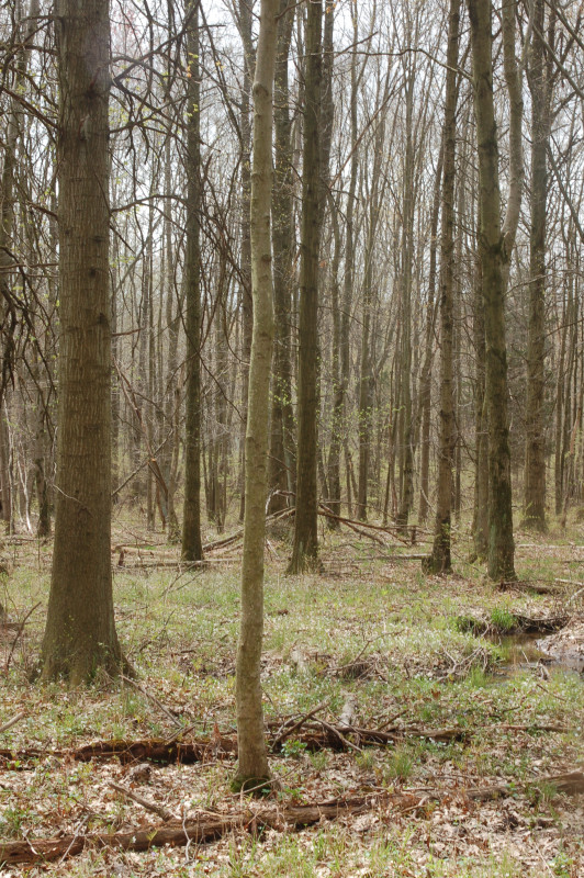
The Oak – Mixed Hardwood Palustrine Forest community occurs in seasonally inundated depressions and floodplains of smaller tributaries in flat-bottomed valleys throughout Pennsylvania. It is found on sandy loams or clay soils of glacial lakeplains, or on soils with impermeable subsoils in unglaciated regions. There is generally some layer that impedes drainage.
This community is characterized by a closed canopy forest, dominated by pin oak (Quercus palustris) and swamp white oak (Quercus bicolor). Associate canopy species may include red maple (Acer rubrum), blackgum (Nyssa sylvatica), black ash (Fraxinus nigra), American elm (Ulmus americana), green ash (Fraxinus pennsylvanica), and bitternut hickory (Carya cordiformis). The understory vegetation is generally sparse, but varies considerably depending on site hydrology and light availability. Under more open canopies, the shrub layer contains buttonbush (Cephalanthus occidentalis), winterberry (Ilex verticillata), arrow-wood (Viburnum recognitum), spicebush (Lindera benzoin), and highbush blueberry (Vaccinium corymbosum). The sparse herbaceous layer includes sedges (Carex intumescens, Carex. lurida, Carex crinita, Carex bromoides), skunk-cabbage (Symplocarpus foetidus), turtlehead (Chelone glabra), jewelweed (Impatiens spp.), tearthumb (Persicaria sagittata), clear weed (Pilea pumila), rice cutgrass (Leersia oryzoides), sensitive fern (Onoclea sensibilis), stout woodreed (Cinna arundinacea), marsh fern (Thelypteris palustris), cinnamon fern (Osmunda cinnamomea), beggar-ticks (Bidens frondosa), water-pepper (Persicaria punctata), floating mannagrass (Glyceria septentrionalis), fowl mannagrass (Glyceria striata), slender mannagrass (Glyceria melicaria), bugleweed (Lycopus uniflorus), clearweed (Pilea pumila), false nettle (Boehmeria cylindrica), and other species tolerant of lower light conditions. These wetlands may also contain a substantial bryophyte layer that includes several peat moss (Sphagnum spp.) species or may be completely devoid of vegetation altogether (in dense shade and/or where seasonal flooding occurs).
Rank Justification
Imperiled in the nation or state because of rarity due to very restricted range, very few populations (often 20 or fewer), steep declines, or other factors making it very vulnerable to extirpation from the nation or state.
Identification
- Poorly drained depressions in basin areas that are seasonally wet (winter and early spring), but can be dry in late summer and early fall
- Mucky soils and little peat development
- Canopy dominated by pin oak and/or swamp white oak
- Occurs in poorly drained depressions in basin areas and floodplains that are seasonally wet
- Rainwater, floodwater or groundwater fed
Trees
Shrubs
Herbs
- Sedge (Carex intumescens)
- Sedge (Carex lurida)
- Short hair sedge (Carex crinita var. crinita)
- Sedge (Carex bromoides)
- Skunk cabbage (Symplocarpus foetidus)
- Turtlehead (Chelone glabra)
- Jewelweed (Impatiens spp.)
- Tearthumb (Persicaria sagittata)
- Clearweed (Pilea pumila)
- Rice cutgrass (Leersia oryzoides)
- Cutgrass (Leersia virginica)
- Sensitive fern (Onoclea sensibilis)
- Cinnamon fern (Osmunda cinnamomea)
- Wood reedgrass (Cinna arundinacea)
- Marsh fern (Thelypteris palustris)
- Beggar-ticks (Bidens frondosa)
- Dotted smartweed (Persicaria punctata)
- Floating mannagrass (Glyceria septentrionalis)
- Fowl mannagrass (Glyceria striata)
- Slender mannagrass (Glyceria melicaria)
- Bugleweed (Lycopus uniflorus)
- False nettle (Boehmeria cylindrica)
* limited to sites with higher soil calcium
Vascular plant nomenclature follows Rhoads and Block (2007). Bryophyte nomenclature follows Crum and Anderson (1981).
International Vegetation Classification Associations:
USNVC Crosswalk:None
Representative Community Types:
Northeastern Pin Oak - Swamp White Oak Forest (CEGL006240)
Pin Oak Small River Floodplain Forest (CEGL006185)
NatureServe Ecological Systems:
Central Appalachian River Floodplain (CES202.608)
NatureServe Group Level:
None
Origin of Concept
Fike, J. 1999. Terrestrial and palustrine plant communities of Pennsylvania. Pennsylvania Natural Diversity Inventory. Pennsylvania Department of Conservation and Recreation, Bureau of Forestry, Harrisburg, PA. 86 pp.
Zimmerman, E., and G. Podniesinski. 2008. Classification, Assessment and Protection of Floodplain Wetlands of the Ohio Drainage. Pennsylvania Natural Heritage Program, Western Pennsylvania Conservancy, Pittsburgh, PA. Report to: The United States Environmental Protection Agency and the Pennsylvania Department of Conservation and Natural Resources, Office of Conservation Science. US EPA Wetlands Protection State Development Grant no. CD-973081-01-0., Leppo 2009
Pennsylvania Community Code*
UA : Bottomland Oak – Hardwood Palustrine Forest
*(DCNR 1999, Stone 2006)
Similar Ecological Communities
This community type is distinguished from the various red maple palustrine forest types (Red Maple – Black Ash Palustrine Forest and Red Maple – Black Gum Palustrine Forest) by the dominance or near-dominance of pin oak (Quercus palustris), and/or swamp white oak (Quercus bicolor).
Fike Crosswalk
Bottomland oak - hardwood palustrine forest
Conservation Value
The community is important habitat for reptile and amphibian species such as wood frogs (Rana sylvatica), spotted salamander (Ambystoma maculatum), marbled salamander (Ambystoma opacum), and Jefferson salamander (Ambystoma jeffersonianum). The oaks also produce acorn mast which is an important food item for many wildlife species such as small and large mammals. This community also serves as a buffer for sediment and pollution runoff from adjacent developed lands by slowing the flow of surficial water causing sediment to settle within this wetland.
Threats
Alteration to the current hydrological regime and overstory clearing are the two important threats to this community and can lead to habitat destruction and/or shifts in community function and dynamics. The emerald ash borer (Agrilus planipennis) may result in the decline or loss of green and black ash from this community in the near future. Development of adjacent land can lead to an accumulation of agricultural run-off and pollution, as well as sedimentation. Invasive plant species such as Japanese knotweed (Fallopia japonica), moneywort (Lysimachia nummularia), and Japanese stiltgrass (Microstegium vimineum) can be common in this community.
Management
Direct impacts to the floodplain ecosystems (e.g., road construction, development, filling of wetlands) have greatly altered their composition, structure, and function region-wide. Further impacts that alter riparian function of the remaining areas should therefore be avoided. When development is unavoidable, low impact alternatives (e.g., elevated footpaths, boardwalks, bridges, pervious paving) that maintain floodplain processes should be utilized to minimize impacts to natural areas and the plant and animal species within them. Maintenance of natural buffers surrounding high quality examples of floodplain wetlands is recommended in order to minimize nutrient runoff, pollution, and sedimentation. Care should also be taken to control and prevent the spread of invasive species into high quality sites.
As floodplains are dependent on periodic disturbance, natural flooding frequency and duration should be maintained and construction of new dams, levees, or other in-stream modifications should be avoided. Activities resulting in destabilization of the banks or alteration of the disturbance patterns of the site should be avoided. Numerous land use planning recommendations have been proposed to reduce the negative impacts of changing land use on riparian systems. These include protecting riparian buffer habitat, retaining natural areas in developed landscapes, compensating for lost habitat, excluding livestock grazing from riparian areas, providing corridors between riparian and upland habitats, avoiding constructing roads and utility lines through riparian habitat areas, and restoring degraded riparian habitat. Providing the river system some scope to maintain itself may be more cost-effective in the long run than attempts at controlling natural functions through human intervention.
Research Needs
Variations may occur at eco-regional levels. There is a need to collect plot data to characterize variations and guide further classification of this community. There is also a need to further distinguish this type from other oak and red maple-dominated wetlands.
Trends
Oak – Mixed Hardwood Palustrine Forests were probably more common but have declined due wetland draining/filling and clearing of the adjacent lands leading to sedimentation. Wetland protection has helped to prevent decline of these communities. The relative trend for this community is likely stable or may be declining slightly due to development and/or hydrological alterations.
Range Map
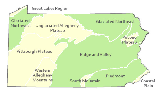
Pennsylvania Range
Glaciated Northeast, Glaciated Northwest, Piedmont, Ridge and Valley.
Global Distribution
This community occurs throughout the northeastern U.S. and has been identified in plant community classifications in Connecticut, Massachusetts, New Jersey, and New York.
Cowardin, L.M., V. Carter, F.C. Golet, and E.T. La Roe. 1979. Classification of wetlands and deepwater habitats of the United States. U.S. Fish and Wildlife Service. Washington, D.C. 131 pp.
Edinger, Gregory J., D.J. Evans, Shane Gebauer, Timothy G. Howard, David M. Hunt, and Adele M. Olivero. 2002. Ecological Communities of New York State. Second Edition. A revised and expanded edition of Carol Reschke's Ecological Communities of New York State. New York Natural Heritage Program, New York State Department of Environmental Conservation. Albany, NY. 136 pp.
Fike, J. 1999. Terrestrial and palustrine plant communities of Pennsylvania. Pennsylvania Natural Diversity Inventory. Harrisburg, PA. 86 pp.
Khan, Nancy R., Ann F. Rhoads, and Timothy A. Block. 2005. Characterization and assessmant of the Floristic Resources in Evansburg State Park. Report submitted to DCNR, Bureau of State Parks.
Khan, Nancy R., Ann F. Rhoads, and Timothy A. Block. 2008. Vascular flora and community assemblages of Evansburg State Park, Montgomery County, Pennsylvania. Bulletin of the Torrey Botanical Club 135(3): 438-458.
Leppo, B., Zimmerman, E., Ray, S., Podniesinski, G., and Furedi, M. 2009. Pennsylvania Statewide Seasonal Pool Ecosystem Classification: Description, mapping, and classification of seasonal pools, their associated plant and animal communities, and the surrounding landscape. Pennsylvania Natural Heritage Program, Western Pennsylvania Conservancy, Pittsburgh, PA.
NatureServe. 2009. NatureServe Central Databases. Arlington, Virginia. USA
Pennsylvania Department of Conservation and Natural Resources (DCNR). 1999. Inventory Manual of Procedure. For the Fourth State Forest Management Plan. Pennsylvania Bureau of Forestry, Division of Forest Advisory Service. Harrisburg, PA. 51 ppg.
Rhoads, Ann F. and Timothy A. Block. 1999. Natural Areas Inventory of Bucks County, Pennsylvania. Bucks County Commissioners, Doylestown, PA.
Rhoads, Ann F. and Timothy A. Block. 2004. East Goshen Township Wetlands; Vegetation Inventory and Management Recommendations. Reoprt submitted to East Goshen Township, Chester County, PA.
Rhoads, Ann F. and Timothy A. Block. 2005. Jacobsburg Environmental Education Center Vegetation Inventory. Report submitted to DCNR, Bureau of State Parks.
Rhoads, Ann F. and Timothy A. Block. 2008. Natural Areas Inventory Update, Montgomery County, Pennsylvania. Montgomery County Planning Commission, Norristown, PA.
Rhoads, Ann F. and Timothy A. Block. 2008. Natural Resources Inventory of French Creek State Park. Report submitted to DCNR, Bureau of State Parks.
Stone, B., D. Gustafson, and B. Jones. 2006 (revised). Manual of Procedure for State Game Land Cover Typing. Commonwealth of Pennsylvania Game Commission, Bureau of Wildlife Habitat Management, Forest Inventory and Analysis Section, Forestry Division. Harrisburg, PA. 79 ppg.

Cite as:
Zimmerman, E. 2022. Pennsylvania Natural Heritage Program. Oak – Mixed Hardwood Palustrine Forest Factsheet. Available from: https://www.naturalheritage.state.pa.us/Community.aspx?=16019 Date Accessed: July 26, 2026


