Great Lakes Bluff Seep
System: Palustrine
Subsystem: Shrubland
PA Ecological Group(s): Great Lakes Region Wetland
Global Rank:GNR
![]() rank interpretation
rank interpretation
State Rank: S1
General Description
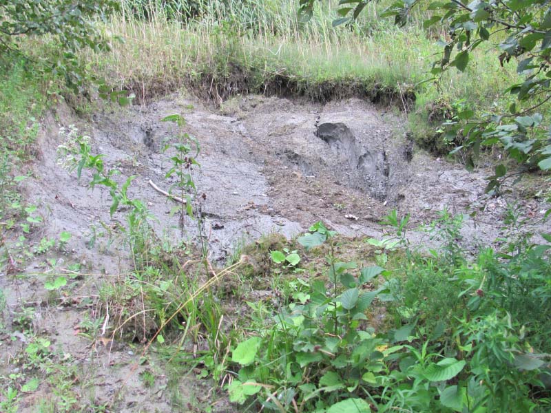
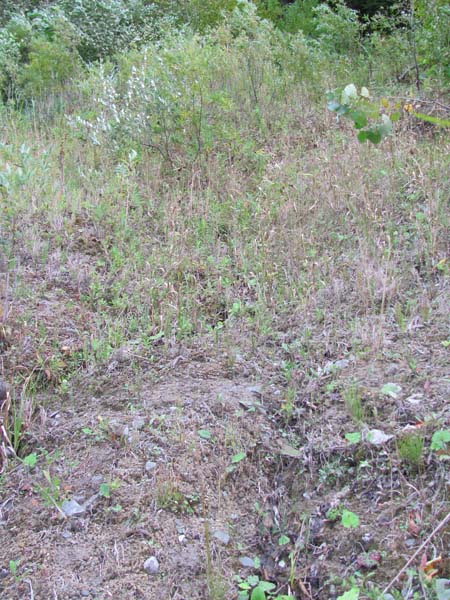
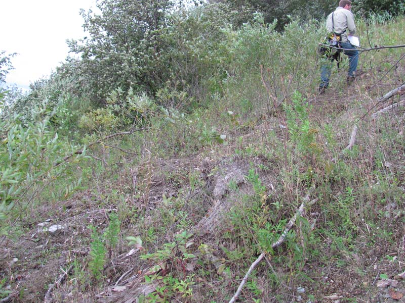
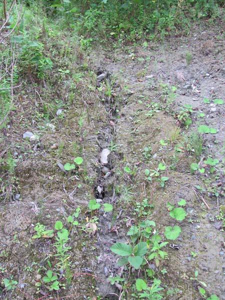
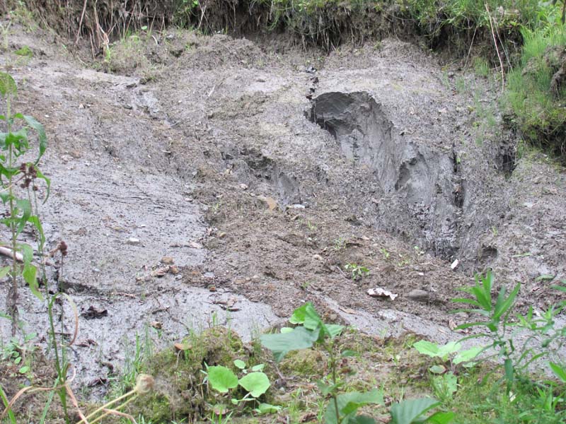
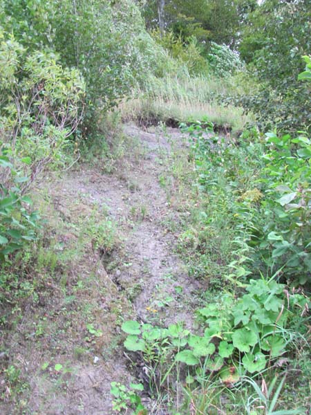
The bluff face communities are characteristically open with a mixture of shrubs and sometimes with scattered trees. This is a very dynamic system and the structure of the vegetation depends largely on its successional status. Recently slumped areas are first colonized by bryophytes and Equisetum spp. (horsetails). As the substrate becomes more stable, and organic matter accumulates, graminoids, other herbs, and shrubs colonize the seep. Eventually, due to erosion from below and perhaps also because of the weight of the vegetation and organic matter, the entire community will slump or slide downslope and the cycle begins again.
Physiognomic differences generally reflect different seral stages in this dynamic system. Common trees and woody species include shadbush (Amelanchier arborea), Canada hemlock (Tsuga canadensis), sugar maple (Acer saccharum), eastern cottonwood (Populus deltoides), hop-hornbeam (Ostrya virginiana), round-leaved dogwood (Cornus rugosa), red-osier dogwood (C. sericea), alternate-leaved dogwood (C. alternifolia), speckled alder (Alnus incana), spicebush (Lindera benzoin), purple-flowering raspberry (Rubus odoratus) willows (Salix spp.), and staghorn sumac (Rhus typhina).
Herbaceous species include zigzag goldenrod (Solidago flexicaulis), jewelweed (Impatiens pallida), field horsetail (Equisetum arvense), grass-of-Parnassus (Parnassia glauca), golden ragwort (Packera aurea), fowl mannagrass (Glyceria striata), golden-fruited sedge (Carex aurea) and brook lobelia (Lobelia kalmii).
Exotic species include common reed (Phragmites australis), purple loosestrife (Lythrum salicaria), and colt’s foot (Tussilago farfara).
Rank Justification
Critically imperiled in the state because of extreme rarity or because of some factor(s) making it especially vulnerable to extirpation from the state. Typically 5 or fewer occurrences or very few remaining individuals or acres.
Identification
- Located on steep slopes of lacustrine sediment, glacial till or shale bedrock, either adjacent to streams or to Lake Erie, in northwestern PA
- Perennial seepage is present along parts of the scarp slope
- Substrate and vegetation may range from bare soil to a shrub layer, depending on where the community is in the cycle of slump and regrowth
Trees
Shrubs
Herbs
- Field horsetail (Equisetum arvense)
- Variegated scouring rush (Equisetum variegatum)
- Small-headed rush (Juncus brachycephalus)
- Zigzag goldenrod (Solidago flexicaulis)
- Pale jewelweed (Impatiens pallida)
- Jewelweed (Impatiens capensis)
- Fowl mannagrass (Glyceria striata)
- Golden-fruited sedge (Carex aurea)
- Alpine rush (Juncus alpinoarticulatus)
* limited to sites with higher soil calcium
Vascular plant nomenclature follows Rhoads and Block (2007). Bryophyte nomenclature follows Crum and Anderson (1981).
International Vegetation Classification Associations:
USNVC Crosswalk:None
Representative Community Types:None
NatureServe Ecological Systems:
Great Lakes Coastal Wetlands Complex (CECX005702)
Great Lakes Alkaline Rocky Shore and Cliff (CES201.995)
Great Lakes Freshwater Estuary and Delta (CES202.033)
NatureServe Group Level:
None
Origin of Concept
Fike, J. 1999. Terrestrial and palustrine plant communities of Pennsylvania. Pennsylvania Natural Diversity Inventory. Pennsylvania Department of Conservation and Recreation, Bureau of Forestry, Harrisburg, PA. 86 pp.
Pennsylvania Community Code*
na : Not Available
*(DCNR 1999, Stone 2006)
Similar Ecological Communities
This type shares characteristics of seepage wetlands and fen communities occurring in the glaciated region of Northwestern Pennsylvania. In contrast to the River Bluff Seeps, which are herbaceous, dominated by grasses and sedges and occurring on steep escarpments of shale bedrock of tributaries to Lake Erie, the Bluffs occurring on the Lake Erie Coast are typically shrubby, with patches of herbaceous cover and occur on the sand, clay or bedrock of the bluffs above the Lake.
In addition, the Great Lakes Bluff Seep may resemble the Calcareous Opening/Cliff Community; however, this is a terrestrial type occurs on calcareous cliffs, outcrops, and rocky slopes throughout the Appalachian Region.
Fike Crosswalk
Related to Great Lakes Region Scarp Seep. This type was modified from Fike (1999) basd on inventory studies of Erie County and community mapping and assessment work at Erie Bluffs State Park by PNHP. This type was separated into two types based on differences in vegetation, geographic location, and substrate observed in the seepage wetlands of the River Bluffs and Lake Erie Bluffs.
Conservation Value
Great Lakes Bluff Seeps are unique to the Great Lakes Ecoregion, where they are limited to the steep bluff slopes above the Lake Erie shore. While historically rare in Pennsylvania due to limited lake frontage, much of the historic area has been greatly impacted by development and agriculture.
Exposed areas along the lakeshore bluffs are important nesting areas for bank swallows (Riparia riparia). This type supports several rare plants including grass-of-Parnassus (Parnassia glauca), golden-fruited sedge (Carex aurea), brook lobelia (Lobelia kalmii), variegated scouring rush (Equisetum variegatum), smallhead rush (Juncus brachycephalus), and alpine rush (Juncus alpinoarticulatus).
Threats
The greatest threats to these communities are direct physical disturbance, invasive plant species, and hydrological alterations affecting groundwater flows to the seeps along the bluffs. The slumping, or retreat, of the bluff escarpments is due to a combination of natural and anthropogenic forces. This action can be exacerbated by anthropogenic activity, including developments on the bluffs or alteration of groundwater flow from activities that increase or decrease groundwater flow or changes in the amount of impervious surface within the basin. The rate of slumping is thought to have increased in recent decades due to reduced long-shore sand transport.
Invasion of non-native plant species such as colt’s foot (Tussilago farfara), common reed (Phragmites australis), and European alder (Alnus glutinosa) threaten native plants and may alter physical and chemical processes along the bluffs.
Management
Great Lakes Bluff Seeps occur in an environmental setting where disturbance, in the form of soil collapse on the steep slopes, is naturally frequent. In one study by Pennsylvania Department of Environmental Protection’s Coastal Zone Management Program, researchers documented bluff recession at five control points along the escarpment top at what is now Erie Bluffs State Park from 1982 to 2003. During this time period, the bluff 14 face lost between 16 and 64 feet, at a rate of 0.75 feet per year to 3.82 feet per year.
The plants of the community are not generally harmed in the long-term by slumps. However, upslope disturbances to the deep glacial soils or bedrock could destabilize these habitats and should be avoided. They are somewhat sensitive habitats, and as steep slopes are frequently attractive to hikers and climbers, care should be taken when accessing these sites. While the steep terrain and unstable, often saturated soils prevent most development, trail construction along the top of lakeshore bluffs should be limited to avoid impacting high-quality examples of this community. Care should also be taken to control and prevent the spread of invasive species.
This community should be protected as a part of a large system of scarp woodlands, forested seeps, lakeplain forests and tributary ravines. Protecting larger landscape will ensure flow of nutrients and plant propagules, and facilitate wildlife movement between patches of similar habitat.
Research Needs
Insects, including lepidopterans may form a substantial part of the biodiversity in these communities, relatively little inventory work has been done for these taxa. There is a continuing need to survey and document high quality examples of this community in Pennsylvania to understand distribution patterns and guide future classification of this association.
Although the basic pattern of succession in these communities is understood, the response of individual plant species populations to slumps is not fully documented. This is especially important for the species of special concern in Pennsylvania.
Trends
The current extent of this community in Pennsylvania and in the larger Great Lakes region is not known. Long, continuous examples of this community have been fragmented by development and their acreage in Pennsylvania has declined as a result of development and recreation. Invasive species, especially giant reed, continue to threaten the quality of the bluff community.
Range Map
Pennsylvania Range
Northwestern Pennsylvania
Global Distribution
Northeastern Ohio to New York along the southern shore of Lake Erie.
Byers, E. A., J. P. Vanderhorst, and B. P. Streets. 2007. Classification and conservation assessment of high elevation wetland communities in the Allegheny Mountains of West Virginia. West Virginia Natural Heritage Program, West Virginia Division of Natural Resources, Elkins.
CAP [Central Appalachian Forest Working Group]. 1998. Central Appalachian Working group discussions. The Nature Conservancy, Boston, MA.
Clancy, K. 1996. Natural communities of Delaware. Unpublished review draft. Delaware Natural Heritage Program, Division of Fish and Wildlife, Delaware Division of Natural Resources and Environmental Control, Smyrna, DE. 52 pp.
Cowardin, L. M., V. Carter, F. C. Golet, and E. T. LaRoe. 1979. Classification of wetlands and deepwater habitats of the United States. U.S. Fish and Wildlife Service, Biological Service Program. FWS/OBS-79/31. Washington, DC. 103 pp.
Dahl, T.E. 1990. Wetlands losses in the United States 1780's to 1980's. U.S. Department of the Interior, Fish and Wildlife Service. Washington, D.C. http://www.npwrc.usgs.gov/resource/othrdata/wetloss/wetloss.htm (Version 16JUL97).
Dahl, T.E. 2006. Status and trends of wetlands in the conterminous United States 1998 to 2004. U.S. Department of the Interior; Fish and Wildlife Service, Washington, D.C. 112 pp.
Eastern Ecology Working Group of NatureServe. No date. International Ecological Classification Standard: International Vegetation Classification. Terrestrial Vegetation. NatureServe, Boston, MA.
Edinger, G. J., D. J. Evans, S. Gebauer, T. G. Howard, D. M. Hunt, and A. M. Olivero, editors. 2002. Ecological communities of New York state. Second edition. A revised and expanded edition of Carol Reschke's ecological communities of New York state. (Draft for review). New York Natural Heritage Program, New York State Department of Environmental Conservation, Albany, NY.
Fike, J. 1999. Terrestrial and palustrine plant communities of Pennsylvania. Pennsylvania Natural Diversity Inventory. Pennsylvania Department of Conservation and Recreation. Bureau of Forestry. Harrisburg, PA. 86 pp.
Gawler, S. C. 2002. Natural landscapes of Maine: A guide to vegetated natural communities and ecosystems. Maine Natural Areas Program, Department of Conservation, Augusta, ME. [in press]
Harrison, J. W., compiler. 2004. Classification of vegetation communities of Maryland: First iteration. A subset of the International Classification of Ecological Communities: Terrestrial Vegetation of the United States, NatureServe. Maryland Natural Heritage Program, Maryland Department of Natural Resources, Annapolis. 243 pp.
Hill, A. F. 1923. The vegetation of the Penobscot Bay region, Maine. Proceedings of the Portland Society of Natural History 3:307-438.
NatureServe 2010. NatureServe Explorer: An online encyclopedia of life Version 7.1. NatureServe, Arlington, VA. Available http://www.natureserv.org/explorer (accessed: 23 November 2011).
Northern Appalachian Ecology Working Group. 2000. Northern Appalachian / Boreal Ecoregion community classification (Review Draft). The Nature Conservancy, Eastern Conservation Science Center, Boston, MA. 117 pp. plus appendices.
Pennsylvania Department of Conservation and Natural Resources (DCNR). 1999. Inventory Manual of Procedure. For the Fourth State Forest Management Plan. Pennsylvania Bureau of Forestry, Division of Forest Advisory Service. Harrisburg, PA. 51 ppg.
Sperduto, D. D. 2000b. A classification of wetland natural communities in New Hampshire. New Hampshire Natural Heritage Inventory, Department of Resources and Economic Development, Division of Forests and Lands. Concord, NH. 156 pp.
Stone, B., D. Gustafson, and B. Jones. 2006 (revised). Manual of Procedure for State Game Land Cover Typing. Commonwealth of Pennsylvania Game Commission, Bureau of Wildlife Habitat Management, Forest Inventory and Analysis Section, Forestry Division. Harrisburg, PA. 79 ppg.
Swain, P. C., and J. B. Kearsley. 2000. Classification of natural communities of Massachusetts. July 2000 draft. Natural Heritage and Endangered Species Program, Massachusetts Division of Fisheries and Wildlife. Westborough, MA.
Thompson, E. 1996. Natural communities of Vermont uplands and wetland. Nongame and Natural Heritage Program, Department of Fish and Wildlife in cooperation with The Nature Conservancy, Vermont chapter. 34 pp.
Thompson, E. H., and E. R. Sorenson. 2000. Wetland, woodland, wildland: A guide to the natural communities of Vermont. The Nature Conservancy and the Vermont Department of Fish and Wildlife. University Press of New England, Hanover, NH. 456 pp.

Cite as:
McPherson, J. and Zimmerman, E. 2022. Pennsylvania Natural Heritage Program. Great Lakes Bluff Seep Factsheet. Available from: https://www.naturalheritage.state.pa.us/Community.aspx?=16040 Date Accessed: July 29, 2026


