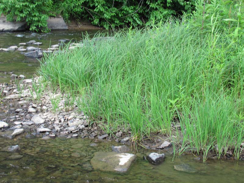
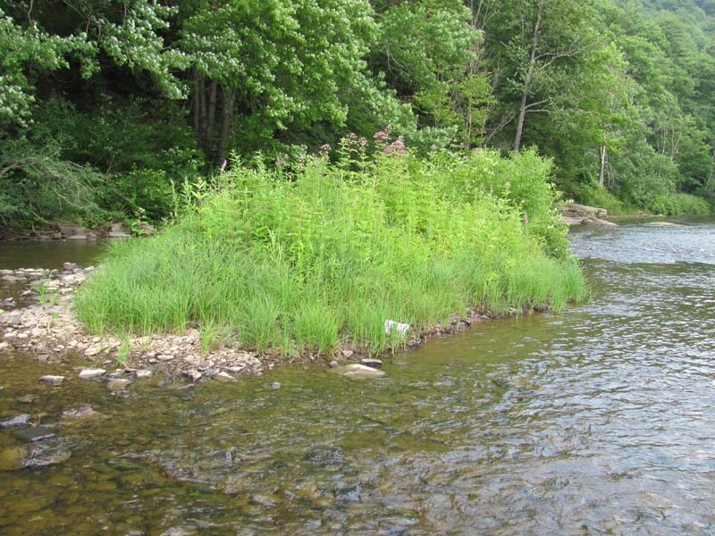
Twisted Sedge (Carex Torta) Stream Margin
System: Palustrine
Subsystem: Herbaceous
PA Ecological Group(s):
River Floodplain
Global Rank:G3G4
![]() rank interpretation
rank interpretation
State Rank: S4
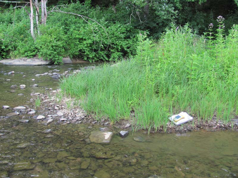
General Description
This community is found throughout Pennsylvania on smaller tributaries within the major river basins. It occurs at or near the water’s edge on island heads, sandy bars, low river banks and in other areas that experience frequent floods, high stream velocity, and ice scour. The soil is typically sand to sandy loam over cobble and gravel, occasionally overlain with a thin layer of muck. Bare cobbles or the Periodically Exposed Shoreline Community often separate this type from flowing water.
Twisted sedge (Carex torta), Joe-Pye-weed, (Eutrochium fistulosum), and pale St. John’s-wort (Hypericum ellipticum) are typically the dominant species, covering 30% to 100% of the area. A wide variety of other graminoid and herbaceous species can be present. The most common species are reed canary-grass (Phalaris arundinacea), sensitive fern (Onoclea sensibilis), Indian-hemp (Apocynum cannabinum), pink dogbane (Apocynum androsaemifolium), field horsetail (Equisetum arvense), grass-leaved goldenrod (Euthamia graminifolia), late goldenrod (Solidago gigantea), bugleweed (Lycopus uniflorus), deer-tongue grass (Dichanthelium clandestinum), violets (Viola spp.), Virginia cutgrass (Leersia virginica), false nettle (Boehmeria cylindrica), boneset (Eupatorium perfoliatum), cardinal-flower (Lobelia siphilitica), and marsh St. John’s-wort (Triadenum virginianum). Scattered short shrubs may be present, including black willow (Salix nigra), diamond willow (Salix eriocephala), river birch (Betula nigra), and meadow-sweet (Spiraea alba).
Rank Justification
Uncommon but not rare; some cause for long-term concern due to declines or other factors.
Identification
- Dominated by twisted sedge (Carex torta), Joe-Pye-weed, (Eutrochium fistulosum), and pale St. John’s-wort (Hypericum ellipticum)
- Contains a diverse mix of forbs and grasses
- Soils are alluvial and range from deep sand deposits to shallow sand and gravel alluvium over cobble
- Occurs at or just above the flowing water
- Maintained by annual episodes of high intensity flooding and ice scour
Shrubs
Herbs
- Twisted sedge (Carex torta)
- Joe-pye-weed (Eutrochium fistulosum)
- Pale St. John's-wort (Hypericum ellipticum)
- Sensitive fern (Onoclea sensibilis)
- Indian hemp (Apocynum cannabinum)
- Pink dogbane (Apocynum androsaemifolium)
- Smooth goldenrod (Solidago gigantea)
- Bugleweed (Lycopus uniflorus)
- Deer-tongue grass (Dichanthelium clandestinum)
- Violets (Viola spp.)
- Cutgrass (Leersia virginica)
- False nettle (Boehmeria cylindrica)
- Boneset (Eupatorium perfoliatum)
- Great blue lobelia (Lobelia siphilitica)
- Marsh St. John's-wort (Triadenum virginicum)
* limited to sites with higher soil calcium
Vascular plant nomenclature follows Rhoads and Block (2007). Bryophyte nomenclature follows Crum and Anderson (1981).
International Vegetation Classification Associations:
USNVC Crosswalk:None
Representative Community Types:
Rocky Bar and Shore (Twisted Sedge Type) (CEGL004103)
NatureServe Ecological Systems:
Central Appalachian River Floodplain (CES202.608)
NatureServe Group Level:
None
Origin of Concept
Zimmmerman 2008
Pennsylvania Community Code*
HX : Golden Saxifrage – Sedge Rich Seep
*(DCNR 1999, Stone 2006)
Similar Ecological Communities
The Periodically Exposed Shoreline Community contains many of the same species as the Twisted Sedge (Carex Torta) Stream Margin; however, it is considerably less vegetated as it represents sparsely vegetated banks, gravel spits, and shores that are underwater much of the year. The plant composition of the Periodically Exposed Shoreline Community often contains many more exotic species. Floodplain Meadow differs from the Twisted Sedge (Carex Torta) Stream Margin in species composition and position on the floodplain. Floodplain Meadow community is typically less frequently scoured/flooded. Soils also are much deeper and the composition is typically more diverse than the Twisted Sedge (Carex Torta) Stream Margin.
Fike Crosswalk
None. This type is new to the Pennsylvania Plant Community Classification developed from river floodplain classification studies in the Susquehanna and Ohio River Basins.
Conservation Value
This community, while common, provides habitat for a number of important and rare insect species, namely tiger beetles (genus Cicindela), ground beetles (order Carabidae), and others. Twisted Sedge (Carex Torta) Stream Margin patches are important breeding, nesting, and foraging areas for several rare dragonflies and damselflies.
Threats
Alteration to the frequency and duration of flood events and development of the river floodplains are the two greatest threats to this community statewide and can lead to habitat destruction and/or shifts in community function and dynamics. Development of adjacent land can lead to an accumulation of agricultural run-off, sedimentation, and pollution.
In addition, reed canary-grass (Phalaris arundinacea), Japanese knotweed (Fallopia japonica), giant knotweed (F. sachalinense), and purple loosestrife (Lythrum salicaria) may invade sites supporting the Twisted Sedge (Carex Torta) Stream Margin; however, vulnerable sites tend to be those with deeper sand deposits. Construction of flood-control and navigational dams has resulted in drastic changes to the timing and duration of flood events. These dams have, in some cases, slowed the river flow resulting in deposition of finer sediments favored by the invasive plants. Twisted sedge tends not to persist in riverine impoundments with slow-moving water and is usually replaced by vegetation more suited to those conditions.
Management
Direct impacts to the floodplain ecosystems (e.g., road construction, development, filling of wetlands) have greatly altered their composition, structure, and function region-wide. Further impacts that alter riparian function of the remaining areas should therefore be avoided. When development is unavoidable, low impact alternatives (e.g., elevated footpaths, boardwalks, bridges, pervious paving) that maintain floodplain processes should be utilized to minimize impacts to natural areas and the plant and animal species within them. Maintenance of natural buffers surrounding high quality examples of floodplain wetlands is recommended in order to minimize nutrient runoff, pollution, and sedimentation. Care should also be taken to control and prevent the spread of invasive species into high quality sites.
As floodplains are dependent on periodic disturbance, natural flooding frequency and duration should be maintained and construction of new dams, levees, or other in-stream modifications should be avoided. Activities resulting in destabilization of the banks or alteration of the disturbance patterns of the site should be avoided. Numerous land use planning recommendations have been proposed to reduce the negative impacts of changing land use on riparian systems. These include protecting riparian buffer habitat, retaining natural areas in developed landscapes, compensating for lost habitat, excluding livestock grazing from riparian areas, providing corridors between riparian and upland habitats, avoiding the construction of roads and utility lines through riparian habitat areas, and restoring degraded riparian habitat. Providing the river system some scope to maintain itself may be more cost-effective in the long run than attempts at controlling natural functions through human intervention.
Research Needs
Variations may occur at ecoregional levels. There is need to assess and quantify soils, site hydrology, and other factors to further assess differences between Twisted Sedge (Carex Torta) Stream Margin occurrences on the Ohio, Delaware, and Susquehanna river basins.
Trends
There is little to suggest that this type is increasing or decreasing in occurrence. Invasive plants able to tolerate flooded conditions may gain a foothold in these sites and contribute to an overall reduction in quality region-wide. Sites supporting this type near urban areas are typically most invaded.
Range Map
Pennsylvania Range
Statewide
Global Distribution
Alabama, Delaware, Georgia, Kentucky, Maryland, North Carolina, Pennsylvania, South Carolina, Tennessee, Virginia, and West Virginia.
Baker, M.E., and B.V. Barnes. 1998. Landscape ecosystem diversity of river floodplains in northwestern Lower Michigan, U.S.A. Canadian Journal of Forestry Research 28: 1405-1418.
Cowardin, L.M., V. Carter, F.C. Golet, and E.T. La Roe. 1979. Classification of wetlands and deepwater habitats of the United States. U.S. Fish and Wildlife Service. Washington, D.C. 131 pp.
Edinger, Gregory J., D.J. Evans, Shane Gebauer, Timothy G. Howard, David M. Hunt, and Adele M. Olivero. 2002. Ecological Communities of New York State. Second Edition. A revised and expanded edition of Carol Reschke's Ecological Communities of New York State. New York Natural Heritage Program, New York State Department of Environmental Conservation. Albany, NY. 136 pp.
Fike, J. 1999. Terrestrial and palustrine plant communities of Pennsylvania. Pennsylvania Natural Diversity Inventory. Harrisburg, PA. 86 pp.
Gregory, S.V., F.J. Swanson, W.A. McKee, and K.W. Cummins. 1991. An ecosystem perspective of riparian zones. Bioscience 41: 540-551.
NatureServe. 2009. International Ecological Classification Standard: International Vegetation Classification. Central Databases. NatureServe, Arlington, VA. Available http://www.natureserve.org/explorer.
NatureServe. 2009. NatureServe Central Databases. Arlington, Virginia. USA
Pennsylvania Department of Conservation and Natural Resources (DCNR). 1999. Inventory Manual of Procedure. For the Fourth State Forest Management Plan. Pennsylvania Bureau of Forestry, Division of Forest Advisory Service. Harrisburg, PA. 51 ppg.
Pennsylvania Natural Heritage Program. 2004. Classification, Assessment and Protection of Non-Forested Floodplain Wetlands of the Susquehanna Drainage. Report to: The United States Environmental Protection Agency and the Pennsylvania Department of Conservation and Natural Resources, Bureau of Forestry, Ecological Services Section. US EPA Wetlands Protection State Development Grant no. CD-98337501.
Stone, B., D. Gustafson, and B. Jones. 2006 (revised). Manual of Procedure for State Game Land Cover Typing. Commonwealth of Pennsylvania Game Commission, Bureau of Wildlife Habitat Management, Forest Inventory and Analysis Section, Forestry Division. Harrisburg, PA. 79 ppg.
Ward, J.V. 1998. Riverine landscapes: Biodiversity patterns, disturbance regimes, and aquatic conservation. Biological Conservation 83: 269-278.
Zimmerman, E., and G. Podniesinski. 2008. Classification, Assessment and Protection of
Floodplain Wetlands of the Ohio Drainage. Pennsylvania Natural Heritage Program, Western Pennsylvania Conservancy, Pittsburgh, PA. Report to: The United States Environmental Protection Agency and the Pennsylvania Department of Conservation and Natural Resources, Office of Conservation Science. US EPA Wetlands Protection State Development Grant no. CD-973081-01-0.
 herbaceous riverine community.jpg)
 herbaceous riverine community02.jpg)
Cite as:
Zimmerman, E. 2022. Pennsylvania Natural Heritage Program. Twisted Sedge (Carex Torta) Stream Margin Factsheet. Available from: https://www.naturalheritage.state.pa.us/Community.aspx?=30021 Date Accessed: July 29, 2026


