Bitternut Hickory Floodplain Forest
System: Palustrine
Subsystem: Forest
PA Ecological Group(s): River Floodplain
Global Rank:G2G3
![]() rank interpretation
rank interpretation
State Rank: S3
General Description
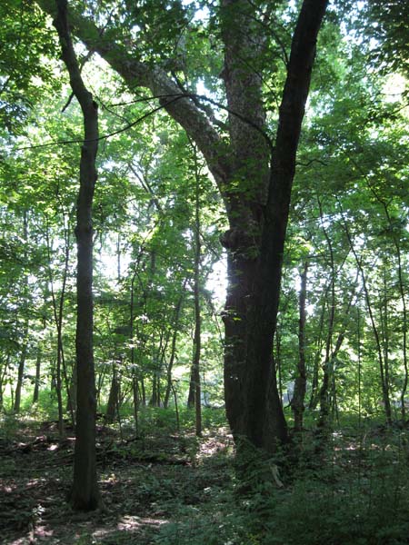
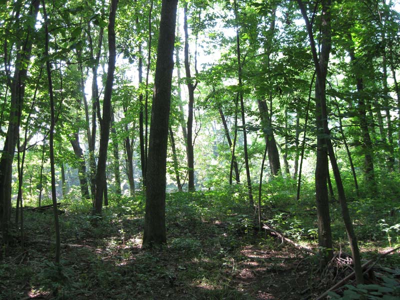
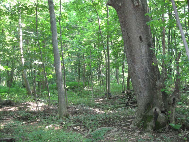
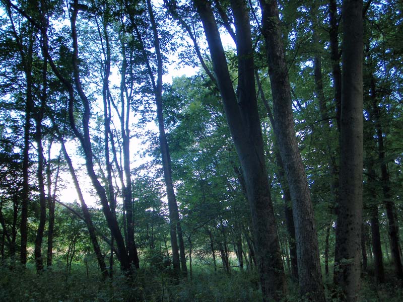
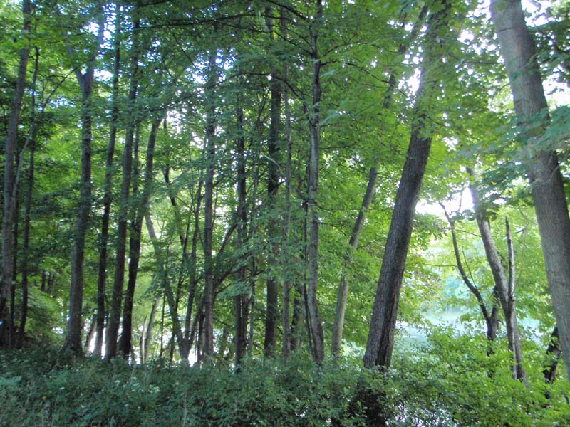
This forest occurs on mid to high floodplain terraces of mid- to large-sized rivers. It is currently documented from the Delaware, Allegheny, and Cheat rivers and probably occurs on other rivers within the region. Flood frequency is unknown, but it is likely flooded less often than Sycamore – Mixed Hardwood Floodplain Forest and Silver Maple Floodplain Forest found on lower floodplain terraces. Soils on these stabilized terraces are derived from alluvial deposits and consist of fine sandy loams and loamy fine sand.
The canopy is usually somewhat open, although occasionally closed, dominated by bitternut hickory (Carya cordiformis). Co-dominant or associate canopy species include northern red oak (Quercus rubra), butternut (Juglans cinerea), black cherry (Prunus serotina), American elm (Ulmus americana), white ash (Fraxinus americana), and silver maple (Acer saccharinum). The relatively sparse subcanopy is similar to the canopy layer and may also include hornbeam (Carpinus caroliniana), red maple (Acer rubrum) and sugar maple (Acer saccharum).
The shrub layer is usually sparse and includes occasional saplings of canopy and subcanopy species, as well as opportunistic native and exotic shrubs such as multiflora rose (Rosa multiflora), Morrow's honeysuckle (Lonicera morrowii), Japanese barberry (Berberis thunbergii), black raspberry (Rubus occidentalis), and prickly dewberry (Rubus flagellaris). The herbaceous layer is weedy, with invasive exotic species common or dominant, including Japanese stiltgrass (Microstegium vimineum), garlic-mustard (Alliaria petiolata), and gill-over-the-ground (Glechoma hederacea). Common native species include white-snakeroot (Ageratina altissima var. altissima), Virginia waterleaf (Hydrophyllum virginianum), and sedges (Carex spp).
Rank Justification
Vulnerable in the jurisdiction due to a restricted range, relatively few populations, recent and widespread declines, or other factors making it vulnerable to extirpation.
Identification
- Found in mid to high floodplain terraces of mid- to large-sized rivers
- Somewhat open canopy dominated or co-dominated by bitternut hickory
- Soils are derived from alluvial deposits and consist of fine sandy loams and loamy fine sand
Trees
- Bitternut hickory (Carya cordiformis)
- American beech (Fagus grandifolia)
- Sycamore (Platanus occidentalis)
- Silver maple (Acer saccharinum)
- Sugar maple (Acer saccharum)
- Wild black cherry (Prunus serotina)
- White ash (Fraxinus americana)
- Green ash, red ash (Fraxinus pennsylvanica)
- Hornbeam (Carpinus caroliniana)
Herbs
Exotic Species
* limited to sites with higher soil calcium
Vascular plant nomenclature follows Rhoads and Block (2007). Bryophyte nomenclature follows Crum and Anderson (1981).
International Vegetation Classification Associations:
USNVC Crosswalk:None
Representative Community Types:
Bitternut Hickory - Black Cherry / White Snakeroot Forest (CEGL006445)
NatureServe Ecological Systems:
Central Appalachian River Floodplain (CES202.608)
NatureServe Group Level:
None
Origin of Concept
Perles, S. J., G. S. Podniesinski, E. Eastman, L. A. Sneddon, and S. C. Gawler. 2007. Classification and Mapping of Vegetation and Fire Fuel Models at Delaware Water Gap National Recreation Area. Technical Report NPS/NER/NRTR—2007/076. National Park Service. Philadelphia, PA.
Pennsylvania Community Code*
SX : Miscellaneous Palustrine/Floodplain Forest
*(DCNR 1999, Stone 2006)
Similar Ecological Communities
Bitternut Hickory Floodplain Forest and Silver Maple Floodplain Forest can have similar species and position on the floodplain. Bitternut Hickory Floodplain Forest is distinguished by the dominance of bitternut hickory (Carya cordiformis) while Silver Maple Floodplain Forest is dominated by silver maple (Acer saccharinum). Bitternut Hickory Floodplain Forest and Sugar Maple – Mixed Hardwood Floodplain Forest can have similar species and position on the floodplain. Bitternut Hickory Floodplain Forest is distinguished by the dominance of bitternut hickory (Carya cordiformis) while Sugar Maple – Mixed Hardwood Floodplain Forest is dominated by sugar maple (Acer saccharum).
Fike Crosswalk
None. This type is new to the Pennsylvania Plant Community Classification developed from NPS Community Classification and mapping studies along the Delaware River and floodplain classification studies in the Ohio River Basin.
Conservation Value
The community is an important part of the river floodplain ecosystem, which provides significant ecosystem services such as sediment control, filtering runoff, and cooling overland flow of water, in addition to wildlife habitat. Great blue herons (Adrea herodias) nest in colonies on river floodplains near their riverine foraging areas. Standing dead trees (snags) provide cavities for bats, wood ducks (Aix sponsa), and other cavity nesting species. Large contiguous floodplain forests provide important habitat for wildlife species requiring large blocks of interior forest, such as neotropical migrants. The dominant species in this community, bitternut hickory (Carya cordiformis), produces mast seed which serves an important role as a food source in mammal population dynamics.
Due to the widespread conversion to agriculture and development, large patches of floodplain forest are uncommon in Pennsylvania and have high conservation significance. Within the river floodplain system, Bitternut Hickory Floodplain Forests are rare and are limited to small patches often occurring within a greater more diverse complex of communities.
Threats
Alteration to the frequency and duration of flood events and development of the river floodplains are the two greatest threats to this community statewide and can lead to habitat destruction and/or shifts in community function and dynamics. Non-native invasive plants may be equally devastating as native floodplain plants are displaced. Development of adjacent land can lead to an accumulation of agricultural run-off, sedimentation, and pollution.
Management
Direct impacts to the floodplain ecosystems (e.g., road construction, development, filling of wetlands) can greatly alter their composition, structure, and function region-wide. Further impacts that alter riparian function of the remaining areas should therefore be avoided. When development is unavoidable, low impact alternatives (e.g., elevated footpaths, boardwalks, bridges, pervious paving) that maintain floodplain processes should be utilized to minimize impacts to natural areas and the plant and animal species within them. Maintenance of natural buffers surrounding high quality floodplain wetlands is recommended in order to minimize nutrient runoff, pollution, and sedimentation.
Care should also be taken to control and prevent the spread of invasive species into high quality sites.
As floodplains are dependent on periodic disturbance, natural flooding frequency and duration should be maintained and construction of new dams, levees or other in-stream modifications should be avoided. Activities resulting in destabilization of the banks or alteration of the disturbance patterns of the site should be avoided. Numerous land use planning recommendations have been proposed to reduce the negative impacts of changing land use on riparian systems. These include protecting riparian buffer habitat, retaining natural areas in developed landscapes, compensating for lost habitat, excluding livestock grazing from riparian areas, providing corridors between riparian and upland habitats, avoiding constructing roads and utility lines through riparian habitat areas, and restoring degraded riparian habitat. In general, unaltered and intact river systems are more resilient to environmental stress than human-impacted or engineered river systems.
Research Needs
The Bitternut Hickory Floodplain Forest has been documented for the Delaware, Allegheny, and Cheat rivers. However, due to the limited occurrences of this type in the Allegheny, it is unclear how widespread this type is within the basin and how and if it differs from the floodplain forests described for the Delaware and Cheat. Bitternut hickory is often a part of mesic floodplain forests in the Ohio River Basin, and it is unclear if it is a distinct type in the Allegheny, or just part of a broader Silver Maple Floodplain Forest type. More work should be done to document and describe the species composition, environmental settings, and distribution of hickory dominated forests within the upper Ohio River Basin. Additionally, there is need to monitor high quality examples of this community type in the Delaware and to determine the impact of invasive species within this type.
Trends
Bitternut Hickory Floodplain Forests were undoubtedly more common historically and have declined due to dam impoundments, human development, and conversion of rich floodplain sites to agriculture; modification of the adjacent upland has further impacted the quality of this type. Conversion of rich floodplain areas to agriculture probably contributed the most to loss of this type across its range. In addition, as this type is dependent upon nutrient input and disturbance from flowing water, alteration of the natural flooding regime (duration and frequency) also contributed to changes in the composition of this type, as species not able to tolerate periodic inundation were able to gain a foothold. The relative trend for this community is most likely declining slightly due to development; however, new alterations to river hydrology could result in significant changes to this type. High quality examples are most likely declining with invasion of exotic plant species, lack of recruitment due to deer browsing, and lack of periodic flooding events.
Range Map
Pennsylvania Range
This type is found in the High Appalachian Plateau Ecoregion, primarily within the Upper Delaware and Upper Allegheny river basins.
Global Distribution
This type is currently documented from New Jersey, New York, Pennsylvania, and West Virginia.
Coladonato, Milo. 1992. Carya cordiformis. In: Fire Effects Information System, [Online]. U.S. Department of Agriculture, Forest Service,
Rocky Mountain Research Station, Fire Sciences Laboratory (Producer).
Available: http://www.fs.fed.us/database/feis/ [2009, November 25].
Cowardin, L.M., V. Carter, F.C. Golet, and E.T. La Roe. 1979. Classification of wetlands and deepwater habitats of the United States. U.S. Fish and Wildlife Service. Washington, D.C. 131 pp.
Edinger, Gregory J., D.J. Evans, Shane Gebauer, Timothy G. Howard, David M. Hunt, and Adele M. Olivero. 2002. Ecological Communities of New York State. Second Edition. A revised and expanded edition of Carol Reschke's Ecological Communities of New York State. New York Natural Heritage Program, New York State Department of Environmental Conservation. Albany, NY. 136 pp.
Fike, J. 1999. Terrestrial and palustrine plant communities of Pennsylvania. Pennsylvania Natural Diversity Inventory. Harrisburg, PA. 86 pp.
NatureServe. 2009. NatureServe Central Databases. Arlington, Virginia. USA
Pennsylvania Department of Conservation and Natural Resources (DCNR). 1999. Inventory Manual of Procedure. For the Fourth State Forest Management Plan. Pennsylvania Bureau of Forestry, Division of Forest Advisory Service. Harrisburg, PA. 51 ppg.
Pennsylvania Natural Heritage Program. 2002. Classification, Assessment and Protection of Forested Floodplain Wetlands of the Susquehanna Drainage. Report to: The United States Environmental Protection Agency and the Pennsylvania Department of Conservation and Natural Resources, Bureau of Forestry, Ecological Services Section. US EPA Wetlands Protection State Development Grant no. CD-993731.
Perles, S. J., G. S. Podniesinski, M. Furedi, B. A. Eichelberger, A. Feldmann, G. Edinger, E. Eastman, and L. A. Sneddon. 2008. Vegetation Classification and Mapping at Upper Delaware Scenic and Recreational River. Technical Report NPS/NER/NRTR—2008/133. National Park Service. Philadelphia, PA.
Stone, B., D. Gustafson, and B. Jones. 2006 (revised). Manual of Procedure for State Game Land Cover Typing. Commonwealth of Pennsylvania Game Commission, Bureau of Wildlife Habitat Management, Forest Inventory and Analysis Section, Forestry Division. Harrisburg, PA. 79 ppg.
Vanderhorst, J. P., B. P. Streets, J. Jeuck, and S. C. Gawler. 2008. Vegetation classification and mapping of Bluestone National Scenic River, West Virginia. Technical Report NPS/NER/NRTR-2008/xxx. National Park Service. Philadelphia, PA.
Walters, G.L. and C.E. Williams. 1999. Riparian forest overstory and herbaceous layer of two upper Allegheny river islands in northwestern Pennsylvania. Castanea 64(1): 81-89.
Walz, K. S., K. Anderson, L. Kelly, and D. Snyder. 2006. Draft New Jersey Ecological
Community Crosswalk. New Jersey Natural Heritage Program, Office of Natural Lands Management, Division of Parks and Forestry, New Jersey Department of Environmental Protection. Trenton, NJ
Zimmerman, E., and G. Podniesinski. 2008. Classification, Assessment and Protection of
Floodplain Wetlands of the Ohio Drainage. Pennsylvania Natural Heritage Program, Western Pennsylvania Conservancy, Pittsburgh, PA. Report to: The United States Environmental Protection Agency and the Pennsylvania Department of Conservation and Natural Resources, Office of Conservation Science. US EPA Wetlands Protection State Development Grant no. CD-973081-01-0.
Cite as:
Perles, SJ 2022. Pennsylvania Natural Heritage Program. Bitternut Hickory Floodplain Forest Factsheet. Available from: https://www.naturalheritage.state.pa.us/Community.aspx?=30003 Date Accessed: July 26, 2026


